Home > Europe > United Kingdom > Northern Ireland > Maps
The Russo-Turkish War, 1877-78, map of the seat of war in Europe

![]()
Wall Art and Photo Gifts from Fine Art Finder
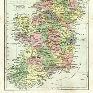
The Russo-Turkish War, 1877-78, map of the seat of war in Europe
3062101 The Russo-Turkish War, 1877-78, map of the seat of war in Europe.; Private Collection; (add.info.: From The Century Edition of Cassell's History of England, published c. 1900)
Media ID 38373422
© Bridgeman Images
Crisis Eastern Empires Ottoman Russo Turkish Russo Turkish War 1877 1878 1877 1878 Russo
FEATURES IN THESE COLLECTIONS
> Asia
> Turkey
> Related Images
> Europe
> Republic of Ireland
> Maps
> Europe
> United Kingdom
> England
> Maps
> Europe
> United Kingdom
> Maps
> Europe
> United Kingdom
> Northern Ireland
> Maps
> Europe
> United Kingdom
> Northern Ireland
> Posters
> Europe
> United Kingdom
> Northern Ireland
> Related Images
> Fine Art Finder
> Artists
> Jingfeng Zhan
> Maps and Charts
> British Empire Maps
> Maps and Charts
> Early Maps
EDITORS COMMENTS
This print captures a pivotal moment in history - The Russo-Turkish War of 1877-78. The detailed map of the seat of war in Europe provides a glimpse into the strategic movements and battles that took place during this conflict between the Russian and Ottoman Empires.
Published around 1900 as part of The Century Edition of Cassell's History of England, this historical illustration offers a window into the past, showcasing the complexities and tensions that defined European politics in the 19th century. From the Eastern front to the heart of Europe, this map highlights key locations and territories that were at stake during this intense period of warfare.
The Russo-Turkish War was not just a military conflict, but also a clash of empires with far-reaching consequences for both regions. It marked a turning point in European history and had lasting implications for the balance of power on the continent.
As we gaze upon this intricate map, we are reminded of the struggles and sacrifices made by those who fought in this war. It serves as a poignant reminder of our shared history and invites us to reflect on how these events continue to shape our world today.
MADE IN THE USA
Safe Shipping with 30 Day Money Back Guarantee
FREE PERSONALISATION*
We are proud to offer a range of customisation features including Personalised Captions, Color Filters and Picture Zoom Tools
SECURE PAYMENTS
We happily accept a wide range of payment options so you can pay for the things you need in the way that is most convenient for you
* Options may vary by product and licensing agreement. Zoomed Pictures can be adjusted in the Cart.