Home > Europe > United Kingdom > England > London > Museums > National Maritime Museum
Caraputo, 1685 (bound sheet)
")
![]()
Wall Art and Photo Gifts from Fine Art Finder
Caraputo, 1685 (bound sheet)
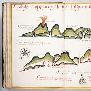
7339727 Caraputo, 1685 (bound sheet) by Hack, William (17th Century); 40x50 cm; National Maritime Museum, London, UK; (add.info.: Creator: William Hack
South America, the Pacific Coast, Ecuador, Caraques and Montechristi. Bound in A Wagoner of the South Sea describing the sea coast from Acapulco to Albemarle isle, an English translation of a Spanish derrotero captured from the Spanish ship Rosario by Captain Bartholomew Sharpe in 1680. Hack made multiple copies of this atlas. This one was presented to James II. It shows Sharpe's track, depicts the silver mine at Potosi, has a decorated title cartouche and scale.); © National Maritime Museum, Greenwich, London
Media ID 38288558
© © National Maritime Museum, Greenwich, London / Bridgeman Images
Coast Line Ecuador Equatorian Equatorians Latin America Latine America
FEATURES IN THESE COLLECTIONS
> Arts
> Artists
> J
> William James
> Europe
> Spain
> Related Images
> Europe
> United Kingdom
> England
> London
> Boroughs
> Greenwich
> Europe
> United Kingdom
> England
> London
> Museums
> Greenwich Heritage Centre
> Europe
> United Kingdom
> England
> London
> Museums
> National Maritime Museum
> Europe
> United Kingdom
> England
> London
> Towns
> Greenwich
> Europe
> United Kingdom
> Heritage Sites
> Maritime Greenwich
> Europe
> United Kingdom
> Maps
> Fine Art Finder
> Artists
> William Hack
EDITORS COMMENTS
This stunning print of Caraputo, 1685 by William Hack transports us back to the 17th century, a time of exploration and adventure. The bound sheet showcases South America's Pacific Coast, specifically Ecuador, Caraques, and Montechristi. It is part of 'A Wagoner of the South Sea', an English translation captured from the Spanish ship 'Rosario' by Captain Bartholomew Sharpe in 1680.
William Hack meticulously crafted multiple copies of this atlas, with one being presented to James II. The detailed map not only shows Sharpe's track but also depicts the silver mine at Potosi and features a beautifully decorated title cartouche and scale.
The vibrant colors used in this artwork bring to life the coastlines and seas depicted on the map. It serves as a reminder of the importance of cartography in exploring new lands during that era.
This print is not just a historical document but also a work of art that captures the essence of maritime exploration in the 17th century. It allows us to appreciate both the skillful craftsmanship involved in creating such maps and the spirit of discovery that drove explorers like Captain Bartholomew Sharpe.
MADE IN THE USA
Safe Shipping with 30 Day Money Back Guarantee
FREE PERSONALISATION*
We are proud to offer a range of customisation features including Personalised Captions, Color Filters and Picture Zoom Tools
SECURE PAYMENTS
We happily accept a wide range of payment options so you can pay for the things you need in the way that is most convenient for you
* Options may vary by product and licensing agreement. Zoomed Pictures can be adjusted in the Cart.