Home > Europe > United Kingdom > Scotland > Highlands > Alness
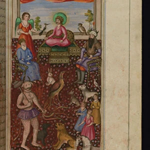
Medieval 10th century World map by Estakhri

![]()
Wall Art and Photo Gifts from Fine Art Finder
Medieval 10th century World map by Estakhri
3507857 Medieval 10th century World map by Estakhri; (add.info.: Medieval 10th century World map by Abu Ishaq Ibrahim ibn Muhammad al-Farisi al Istakhri (Estakhri), A Persian: geographer and cartographer circa 957 AD.); Universal History Archive
Media ID 38465480
© Universal History Archive / Bridgeman Images
10 10th 10th X 10th Century 10 10th X Xth Century 10 Century 10 X X X X X 10th Century C10th Cartographer Iran Iranian Iranians Muslim Religion Persia Persians Tenth Century X Century Xth Century Geographer Late Middle Age Medioeval Middle Ages Medieval Middles Ages
FEATURES IN THESE COLLECTIONS
> Arts
> Art Movements
> Medieval Art
> Asia
> Iran
> Related Images
> Europe
> United Kingdom
> Scotland
> Highlands
> Alness
> Fine Art Finder
> Costume & Fashion
> Maps and Charts
> Related Images
> Maps and Charts
> World
EDITORS COMMENTS
This stunning print captures the intricate details of a Medieval 10th century World map created by Estakhri, a renowned Persian geographer and cartographer. Dating back to around 957 AD, this map offers a fascinating glimpse into the geographical knowledge and artistic skills of the time.
Estakhri's map is not only a testament to his expertise in cartography but also reflects the cultural and religious influences of the era. As an Islamic scholar, Estakhri incorporated elements of Muslim religion and Middle Eastern traditions into his work, making it a valuable historical artifact.
The map itself is a masterpiece of precision and creativity, showcasing various regions from Persia to Europe with remarkable accuracy considering the limited technology available during that period. The intricate patterns and symbols used to represent different territories add an artistic flair to this practical tool for navigation.
As we gaze upon this ancient world map, we are transported back in time to an era where exploration and discovery were at the forefront of human endeavor. It serves as a reminder of how far we have come in our understanding of geography while also highlighting the enduring legacy of scholars like Estakhri who paved the way for future generations.
MADE IN THE USA
Safe Shipping with 30 Day Money Back Guarantee
FREE PERSONALISATION*
We are proud to offer a range of customisation features including Personalised Captions, Color Filters and Picture Zoom Tools
SECURE PAYMENTS
We happily accept a wide range of payment options so you can pay for the things you need in the way that is most convenient for you
* Options may vary by product and licensing agreement. Zoomed Pictures can be adjusted in the Cart.