Home > Animals > Mammals > Cercopithecidae > Mauritius
Map of colonial Africa, c.1900 (engraving)
")
![]()
Wall Art and Photo Gifts from Fine Art Finder
Map of colonial Africa, c.1900 (engraving)
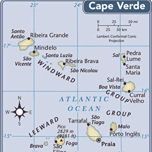
533053 Map of colonial Africa, c.1900 (engraving); (add.info.: Map of colonial Africa, with insets of Ascension Island, St. Helena Island, Reunion, Mauritius, and Cape Verde Islands, circa 1902, from the 10th edition of Encyclopaedia Britannica.); Encyclopaedia Britannica/UIG
Media ID 38406404
© Encyclopaedia Britannica/UIG / Bridgeman Images
1902 19th Century Style Boundary Continent Geographical Border Guidance Illustration Technique Mauritius Meridian Navigational Equipment Old Fashioned Physical Geography Reunion The Past Western Script Ascension Island Cape Verde Islands
FEATURES IN THESE COLLECTIONS
> Africa
> Cape Verde
> Maps
> Africa
> Cape Verde
> Related Images
> Africa
> Mauritius
> Related Images
> Animals
> Mammals
> Cercopithecidae
> Mauritius
> Fine Art Finder
> Temp Classification
> Historic
> Colonial history
> Colonial art and artists
> Maps and Charts
> Related Images
EDITORS COMMENTS
This engraving of a Map of colonial Africa, circa 1900, offers a glimpse into the intricate boundaries and coastlines of the continent during a pivotal period in history. The detailed insets of Ascension Island, St. Helena Island, Reunion, Mauritius, and Cape Verde Islands provide additional insight into the geographical landscape of Africa at that time.
The map exudes an old-fashioned charm with its 19th-century style and Western script labeling various regions and landmarks. It serves as a navigational tool for exploration and discovery, highlighting meridians and seas to guide travelers across the vast African continent.
As we gaze upon this historical artifact, we are transported back to a time when colonial powers were vying for control over territories in Africa. The map symbolizes the complex history of colonization and imperialism that has shaped the continent's present-day borders.
Through this illustration technique, we can appreciate the artistry and precision involved in cartography during the early 20th century. This print from Fine Art Finder is not just a visual representation but also a testament to Africa's rich history and enduring legacy.
MADE IN THE USA
Safe Shipping with 30 Day Money Back Guarantee
FREE PERSONALISATION*
We are proud to offer a range of customisation features including Personalised Captions, Color Filters and Picture Zoom Tools
SECURE PAYMENTS
We happily accept a wide range of payment options so you can pay for the things you need in the way that is most convenient for you
* Options may vary by product and licensing agreement. Zoomed Pictures can be adjusted in the Cart.