Routes Collection (#8)

"Tracing the Pathways: Exploring Routes through Time and Space" Embark on a captivating journey as we delve into the fascinating world of routes

Background imageRoutes Collection: Walkers crossing bridge near farmyard on Coast to Coast Walk, Ravenseat, Keld, Richmond, Swaledale

Walkers crossing bridge near farmyard on Coast to Coast Walk, Ravenseat, Keld, Richmond, Swaledale, Yorkshire Dales N.P. North Yorkshire, England, April

Background imageRoutes Collection: Danger, Beware of fast tides, hidden channels and quick sands warning sign beside road

Danger, Beware of fast tides, hidden channels and quick sands warning sign beside road from coastal village, only community on U.K

Background imageRoutes Collection: Footpath to Edale sign on farm, Edale, Peak District N. P. Derbyshire, England, August

Footpath to Edale sign on farm, Edale, Peak District N. P. Derbyshire, England, August
Footpath to Edale sign on farm, Edale, Peak District N.P. Derbyshire, England, August

Background imageRoutes Collection: Pennine Way and Public Footpath signs on farm, Edale, Peak District N. P

Pennine Way and Public Footpath signs on farm, Edale, Peak District N. P. Derbyshire, England, August
Pennine Way and Public Footpath signs on farm, Edale, Peak District N.P. Derbyshire, England, August

Background imageRoutes Collection: Stone building for walkers beside footpath, Edale, Peak District N. P. Derbyshire, England, August

Stone building for walkers beside footpath, Edale, Peak District N. P. Derbyshire, England, August
Stone building for walkers beside footpath, Edale, Peak District N.P. Derbyshire, England, August

Background imageRoutes Collection: London control zone and associated national airways

London control zone and associated national airways, London Airport inbound and outbound routes. 15 August 1951. Date: 1951

Background imageRoutes Collection: Industrialisation in Russia was led by the introduction of railways. Map circa 1890

Industrialisation in Russia was led by the introduction of railways. Map circa 1890 shows rail routes across Russia

Background imageRoutes Collection: Migration to the Americas, diagram

Migration to the Americas, diagram
Migration to the Americas. Diagram showing the three theories (arrowed) for when and how humans first arrived in the Americas

Background imageRoutes Collection: Gotthard Base Tunnel, artwork

Gotthard Base Tunnel, artwork
Gotthard Base Tunnel. Computer artwork showing the airvent system (red arrows) and escape tunnels (blue arrows) of part of the Gotthard Base Tunnel, Switzerland

Background imageRoutes Collection: Bird migration, artwork C016 / 3449

Bird migration, artwork C016 / 3449
Bird migration. Computer artwork showing the annual migration routes taken by many migratory birds that travel from Europe (top) to Africa (bottom), where they spend the cooler months

Background imageRoutes Collection: Martin China Clipper

Martin China Clipper
The Martin 130 passenger flying boat is used by Pan American on their Pacific routes, carrying 48 passengers to the Philippines. Date: circa 1936

Background imageRoutes Collection: Burma Scene / Dak 1909

Burma Scene / Dak 1909
Dak bungalows are placed at intervals along routes, primarily for the use of government officials but available to other travellers Date: 1909

Background imageRoutes Collection: Cycle path in city, Limehouse, Tower Hamlets, London, England, september

Cycle path in city, Limehouse, Tower Hamlets, London, England, september

Background imageRoutes Collection: Road cleared through snowdrifts, Davos, Graubunden, Swiss Alps, Switzerland, january

Road cleared through snowdrifts, Davos, Graubunden, Swiss Alps, Switzerland, january

Background imageRoutes Collection: Cover design, Imperial Airways map

Cover design, Imperial Airways map of the European Air Routes for 1934: London-Paris, Paris-Basle, Basle-Zurich, London-Brussels, Brussels-Cologne, London-Le Touquet

Background imageRoutes Collection: Cover design, Deruluft timetable

Cover design, Deruluft timetable
Cover design, Deruluft (Deutsch-Russische Luftverkehrsgesellschaft, LVG), serving Berlin and Moscow. circa 1934

Background imageRoutes Collection: Imperial Airways Poster, travel in comfort

Imperial Airways Poster, travel in comfort
Imperial Airways Poster, Travel In Comfort, serving Europe, Africa, India and the East, depicting a globe with routes marked. 20th century

Background imageRoutes Collection: Grand Trunk Railway 1879

Grand Trunk Railway 1879
Grand Trunk Railway of Canada and its connections, 1879 Date: 1879

Background imageRoutes Collection: Passenger Traffic map

Passenger Traffic map
Plan of licensed stage coaches running between London and the East of England, c.1840 Date: c. 1840

Background imageRoutes Collection: Dominion Line steamers

Dominion Line steamers
Dominion Line, Royal mail steamers, weekly sailings between England, American and Canada, 1899 Date: 1899

Background imageRoutes Collection: Empire exports poster

Empire exports poster
Empire Marketing Board 1927-1933 poster, The Empires Highway To India (Exports) Date: 1927-1933

Background imageRoutes Collection: Malta

Malta
Empire Marketing Board 1927-1933 poster, The Empires Highway To India (Malta) Date: 1927-1933

Background imageRoutes Collection: Processional route for the 1937 Coronation

Processional route for the 1937 Coronation
Incredibly detailed aerial view of central London by ILN special artist G.H. Davis showing the processional route to and from Westminster Abbey for the Coronation of King George VI in 1937

Background imageRoutes Collection: Train routes through Eastern Asia

Train routes through Eastern Asia operated by the South Manchurian Railway Co. Date: circa 1905

Background imageRoutes Collection: Coronation. The main column of Pikemen

Coronation. The main column of Pikemen
The main body of the Pikemen and Liverymen of the City of London march past the west door of the Abbey on their way to take up position on the route. 1953

Background imageRoutes Collection: Interpol, Paris, 1960S

Interpol, Paris, 1960S
A drug-smuggling map of the world, with lines showing the routes by which narcotics are taken from country to country. Date: 1960s

Background imageRoutes Collection: Afghanistan / Bolan Pass

Afghanistan / Bolan Pass
Vultures swoop to feed on carrion. The Bolan Pass was one of the routes used by the British to invade Afghanistan in November 1878. Date: 1878

Background imageRoutes Collection: Footpath direction sign, footpath beside paddock and arable field, Bacton, Suffolk, England, october

Footpath direction sign, footpath beside paddock and arable field, Bacton, Suffolk, England, october

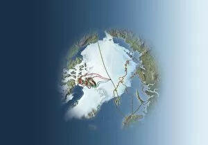
Background imageRoutes Collection: Arctic exploration, route maps

Arctic exploration, route maps
Arctic exploration. Map of the Arctic showing the routes taken by Fridtjof Nansen (1893 to 1896, brown), Frederick Cook (1907 to 1909, red), Robert Peary (1909, blue) and Umberto Nobile (1926)

Background imageRoutes Collection: Mombasa - Kenya - Fort Jesus

Mombasa - Kenya - Fort Jesus
Fort Jesus at Mombasa, Kenya - overlooks the entrance to the old port and was built by the Portuguese between 1593 and 1596 to protect the trade routes to India and East Africa

Background imageRoutes Collection: The Neutral Umbrella

The Neutral Umbrella
A small umbrella of neutrality offers little shelter to Holland, Norway and the USA who find they are all affected either by cutting of their trade routes

Background imageRoutes Collection: Toll reform committee map

Toll reform committee map
A map of London presented to Lord Palmerston by the Toll Reform Committee of 1857. The committee sought to eliminate unnecessary tolls from routes into London

Background imageRoutes Collection: Map of Central Africa showing the likely routes of the Emin

Map of Central Africa showing the likely routes of the Emin
Engraved map showing Central Africa and the predicted routes of the Emin Pasha Relief Expedition, 1887. Emin Pasha (1840-1892), the German doctor, explorer

Background imageRoutes Collection: SHORT CALEDONIA

SHORT CALEDONIA
One of the new generation of monoplane flying boats which will replace the stately old biplanes, this will be used by Imperial Airways on long distance passenger routes

Background imageRoutes Collection: Cant Z. 506 Airone

Cant Z. 506 Airone
The CANT Z-506 Airone (Heron) is a seaplane built for Ala Littorias Adriatic routes; when war comes it will be adapted as a torpedo bomber

Background imageRoutes Collection: IN A FARMAN GOLIATH

IN A FARMAN GOLIATH
The Farman Goliath is Frances principal commercial passenger carrier, employed on such routes as the one to London

Background imageRoutes Collection: Handley Page Hannibal

Handley Page Hannibal
With the near-identical HP42W (= western, i.e. European) Heracles, the stately HP42E (= eastern) Hannibal class are the flagships of Imperial Airways on routes to India etc

Background imageRoutes Collection: Russian Ice Breaker 2

Russian Ice Breaker 2
The YERMAK (variously spelt) built in Britain for the Russians who employ it to clear sea-routes on Lake Baikal

Background imageRoutes Collection: Crowded Air-Lanes

Crowded Air-Lanes
When air travel becomes popular, the sky routes will become as crowded as those on the surface : some kind of air traffic control will surely be needed

Background imageRoutes Collection: Europe Trade W. Asia Map

Europe Trade W. Asia Map
A map showing the extent of European trade with Asia in the 18th century

Background imageRoutes Collection: Mecca Pilgrim Routes

Mecca Pilgrim Routes
Pilgrim-routes to Mecca from Morocco

Background imageRoutes Collection: Italian Steam Tram

Italian Steam Tram
Steam trams are a nuisance in cities, but on rural routes like this Italian example they are economical and provide low cost transportation for low- paid workers


For sale as Licensed Images

Choose your image, Select your licence and Download the media

"Tracing the Pathways: Exploring Routes through Time and Space" Embark on a captivating journey as we delve into the fascinating world of routes, where maps serve as gateways to exploration. From the intricate British Railways network map of the 1950s to the enchanting Trans-Siberian Railway depicted in a vintage engraving from J. Bartholomew & Co. , these routes unveil tales of connectivity and adventure. Transport yourself back to c. 1920 with a mesmerizing map showcasing the legendary Trans-Siberian Railway, an engineering marvel that spans continents and cultures. Meanwhile, an intriguing glimpse into Afghanistan's past unfolds through a historical map from the 1860s, revealing ancient trade routes etched across its rugged terrain. As air travel took flight, Cobham Air Routes Poster captures our imagination with promises of soaring above clouds towards new horizons. The Pacific Line Poster invites us aboard luxurious ocean liners that once sailed vast distances, connecting distant lands like never before. Unveiling global possibilities, Pan American Airways route map showcases intercontinental connections that revolutionized travel in ways unimaginable just decades ago. Spithead & Shoreham Air Ferries Poster takes us closer to home but no less thrillingly; it reminds us how even short flights can open up worlds of opportunity. Beyond land and sky lies another dimension – underwater passages guarded by WW1 naval blockades that shaped history's course forevermore. Compagnie Generale Transatlantique beckons adventurers towards transoceanic voyages while Belgian Railway Poster entices explorers to uncover hidden treasures amidst Flanders' rolling hills. Intriguingly different yet equally captivating are Antarctic exploration route maps which reveal brave souls who dared venture into icy unknowns for scientific discovery and human triumph against nature's harshest elements. Lastly, immerse yourself in Franco-British Exhibition - London Underground plan.