Home > Europe > France > Paris > Maps
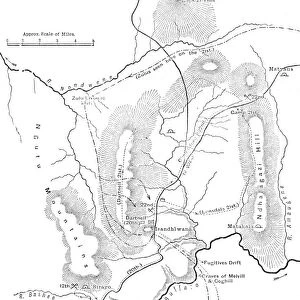
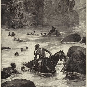
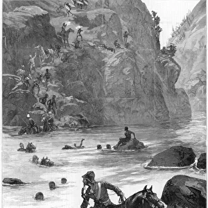
Plan of the Battle of Isandhlwana, (Jan. 22, 1879), c1880
, c1880")
![]()
Wall Art and Photo Gifts from Heritage Images
Plan of the Battle of Isandhlwana, (Jan. 22, 1879), c1880
Plan of the Battle of Isandhlwana, (Jan. 22, 1879), c1880. From British Battles on Land and Sea, Vol. IV, by James Grant. [Cassell Petter & Galpin, London, Paris & Melbourne, c1880]
Heritage Images features heritage image collections
Media ID 14991645
© The Print Collector
Anglo Zulu Wars British Battles On Land And Sea Cassell Petter Galpin Grant Imperialism James Grant Military Operation Petter Galpin Plan Province Of Kwazulu Natal South Africa South African Strategy Zulu Wars Battle Of Isandlwana Battlefield Cassell Isandhlwana
FEATURES IN THESE COLLECTIONS
> Africa
> South Africa
> Maps
> Africa
> South Africa
> Related Images
> Arts
> Literature
> Europe
> France
> Canton
> Landes
> Europe
> France
> Paris
> Maps
> Historic
> Battles
> Related Images
> Maps and Charts
> Related Images
EDITORS COMMENTS
This print takes us back to a significant moment in history - the Battle of Isandhlwana on January 22,1879. The detailed map, dating back to around 1880, offers a glimpse into the strategic planning and military operations during the Anglo-Zulu Wars in South Africa. The print is extracted from James Grant's renowned book "British Battles on Land and Sea" which provides an invaluable account of British imperialism and its encounters with various nations across the globe. This particular illustration showcases the battlefield at Isandhlwana, located in what is now known as the province of KwaZulu-Natal. As we study this monochrome masterpiece, we can't help but be drawn into the intricate lines that depict troop movements and positions. It serves as a reminder of both Britain's military might and their clash with Zulu warriors who fiercely defended their land. The significance of this print lies not only in its historical context but also in its artistic representation. The attention to detail allows us to visualize how battles were planned and executed during this tumultuous period. It serves as a testament to human ingenuity, strategy, and sacrifice. Whether you are an avid reader or simply fascinated by maps and military history, this print will transport you back to a pivotal moment in time when two powerful forces collided on African soil.
MADE IN THE USA
Safe Shipping with 30 Day Money Back Guarantee
FREE PERSONALISATION*
We are proud to offer a range of customisation features including Personalised Captions, Color Filters and Picture Zoom Tools
SECURE PAYMENTS
We happily accept a wide range of payment options so you can pay for the things you need in the way that is most convenient for you
* Options may vary by product and licensing agreement. Zoomed Pictures can be adjusted in the Cart.