Home > Europe > United Kingdom > England > London > Boroughs > Croydon
North Hertfordshire SG8 0 Map

![]()
Wall Art and Photo Gifts from Map Marketing
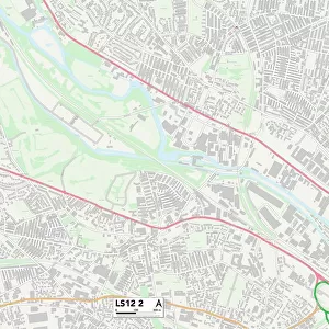
North Hertfordshire SG8 0 Map
Postcode Sector Map of North Hertfordshire SG8 0
Media ID 19981170
Abbotts Close Ashwell Road Ashwell Street Brook End Chapel Close Cherry Tree Close Church End Church Farm Lane Church Lane Church Street Cranes Lane Croydon Croydon Road Fen Road Fox Hill Hay Street High Street Hillside Lane Jubilee Way Little Green Lower Road Malting Lane Meeting Lane Middle Street Mill Lane New Close New Road North Hertfordshire Plough Close Potton Road Royston Road Russell Close Silver Street South Street St Catherines Court Station Road Swan Lane The Green Town Farm Close Westbrook Close Litlington Wendy
FEATURES IN THESE COLLECTIONS
> Europe
> United Kingdom
> England
> Hertfordshire
> Ashwell
> Europe
> United Kingdom
> England
> Hertfordshire
> Church End
> Europe
> United Kingdom
> England
> Hertfordshire
> East End
> Europe
> United Kingdom
> England
> Hertfordshire
> Mill End
> Europe
> United Kingdom
> England
> Hertfordshire
> Green End
> Europe
> United Kingdom
> England
> Hertfordshire
> Green Street
> Europe
> United Kingdom
> England
> Hertfordshire
> Hay Street
> Europe
> United Kingdom
> England
> Hertfordshire
> Related Images
> Europe
> United Kingdom
> England
> Hertfordshire
> Royston
> Europe
> United Kingdom
> England
> London
> Boroughs
> Croydon
> Map Marketing
> Postcode Sector Maps
> SG - Stevenage
MADE IN THE USA
Safe Shipping with 30 Day Money Back Guarantee
FREE PERSONALISATION*
We are proud to offer a range of customisation features including Personalised Captions, Color Filters and Picture Zoom Tools
SECURE PAYMENTS
We happily accept a wide range of payment options so you can pay for the things you need in the way that is most convenient for you
* Options may vary by product and licensing agreement. Zoomed Pictures can be adjusted in the Cart.