Home > Animals > Mammals > Cats (Wild) > Populator
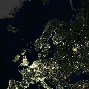
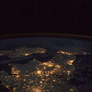
Whole Earth at night, satellite image

![]()
Wall Art and Photo Gifts from Science Photo Library
Whole Earth at night, satellite image
Whole Earth map at night, satellite image. Here, Africa is seen at centre. City lights (yellow) of increasing intensity show areas of increasing population, with areas of few lights being more sparsely populated. Image obtained using data from Landsat 5 and Landsat 7 satellites
Science Photo Library features Science and Medical images including photos and illustrations
Media ID 6281716
© PLANETOBSERVER/SCIENCE PHOTO LIBRARY
Africa Antarctica Arctic Atlantic Australia Cartography Continent Continents Dark Darkness Densely Populated Earth Observation Earth Science From Space Global Greenland Ice Cap Land Landsat 5 Landsat 7 Lights Night Oceania Pacific Pole Poles Population Satellite Satellite Image South America Sparsely Populated Whole Earth World World Wide
FEATURES IN THESE COLLECTIONS
> Africa
> Related Images
> Africa
> South Africa
> Maps
> Africa
> South Africa
> Related Images
> Animals
> Mammals
> Cats (Wild)
> Populator
> Arts
> Artists
> O
> Oceanic Oceanic
> Asia
> Related Images
> Europe
> France
> Canton
> Landes
> Maps and Charts
> Popular Maps
EDITORS COMMENTS
This print showcases the mesmerizing beauty of our planet, captured from space during nighttime. The image reveals the Whole Earth at night, with Africa positioned at its center. As we gaze upon this satellite image, it becomes evident that city lights play a significant role in indicating areas of increasing population density. The vibrant yellow hues represent urban areas and their intensities correlate directly with higher population concentrations. The photograph was obtained using data collected by Landsat 5 and Landsat 7 satellites, providing us with an extraordinary perspective on our world's geography and demographics. From the dark expanses of oceans to the illuminated continents, every corner of Earth is represented within this single frame. As we explore further into this visual masterpiece, we can identify various regions such as Australia, South America, Greenland, Antarctica, Oceania, Asia, Europe and North America. Each landmass carries its own unique characteristics reflected through patterns of light or darkness. This remarkable satellite image not only serves as a testament to human progress but also highlights the delicate balance between densely populated urban centers and sparsely inhabited regions across our globe. It reminds us of both the interconnectedness and vast diversity present on our shared home - Planet Earth.
MADE IN THE USA
Safe Shipping with 30 Day Money Back Guarantee
FREE PERSONALISATION*
We are proud to offer a range of customisation features including Personalised Captions, Color Filters and Picture Zoom Tools
SECURE PAYMENTS
We happily accept a wide range of payment options so you can pay for the things you need in the way that is most convenient for you
* Options may vary by product and licensing agreement. Zoomed Pictures can be adjusted in the Cart.