Home > Europe > United Kingdom > England > Kent > Edenbridge
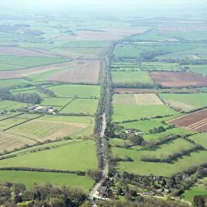
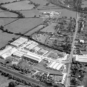
Aerial view of Edenbridge Kent. industrial estate, bottom left is within the town

![]()
Wall Art and Photo Gifts from TopFoto
Aerial view of Edenbridge Kent. industrial estate, bottom left is within the town
Aerial view of Edenbridge Kent.
industrial estate, bottom left is within the town envelope. agricultural land beyond untouched.
15 September 1962
TopFoto independent historic photographs and images all subjects and eras
Media ID 10990324
© John Topham / TopFoto
Industrial Estate Railway Line Roman Road
FEATURES IN THESE COLLECTIONS
> Aerial Photography
> Related Images
> Arts
> Artists
> T
> John Topham
> Europe
> United Kingdom
> England
> Kent
> Edenbridge
> TopFoto
> Nostalgia John Topham's Britain
EDITORS COMMENTS
This aerial view of Edenbridge Kent, taken on 15th September 1962, showcases the town's unique blend of urban and rural landscapes. The photograph captures an industrial estate nestled within the heart of the town, visible as a cluster of buildings in the bottom left corner. Beyond this bustling hub lies vast stretches of untouched agricultural land that extend into the distance, emphasizing Edenbridge's harmonious coexistence with nature. The image also highlights several key features that define this picturesque region. A prominent green belt area surrounds the town, acting as a protective barrier against further urban expansion and preserving its natural beauty. A railway line cuts through the landscape, connecting Edenbridge to other parts of Kent and facilitating transportation for both residents and businesses alike. Atop a hill stands a top station, offering panoramic views over Edenbridge and its surroundings. This vantage point allows visitors to appreciate not only the industrial aspects but also the breathtaking countryside that envelops it. Furthermore, remnants from ancient times are evident in this photo print; a Roman road can be seen traversing through these lands—a testament to Edenbridge's rich historical heritage. This remarkable photograph by Topography encapsulates all these elements beautifully while reminding us of how human development can seamlessly integrate with nature when carefully planned and preserved.
MADE IN THE USA
Safe Shipping with 30 Day Money Back Guarantee
FREE PERSONALISATION*
We are proud to offer a range of customisation features including Personalised Captions, Color Filters and Picture Zoom Tools
FREE COLORIZATION SERVICE
You can choose advanced AI Colorization for this picture at no extra charge!
SECURE PAYMENTS
We happily accept a wide range of payment options so you can pay for the things you need in the way that is most convenient for you
* Options may vary by product and licensing agreement. Zoomed Pictures can be adjusted in the Cart.