Home > Africa > Egypt > Maps
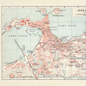
Plan of the old city Alexandria 1895

![]()
Wall Art and Photo Gifts from Fine Art Storehouse
Plan of the old city Alexandria 1895
Meyers Konversations-Lexikon. Ein Nachschlagewerk des allgemeinen Wissens, 5th edition 17 volumes Bibliographisches Institut - Leipzig 1895-1897
Unleash your creativity and transform your space into a visual masterpiece!
THEPALMER
Media ID 13611755
© This content is subject to copyright
Alexandria Egypt Atlas Mythological Figure Egypt Mediterranean Sea Middle East Paper Plan Valley Of The Kings World Map
FEATURES IN THESE COLLECTIONS
> Africa
> Egypt
> Alexandria
> Fine Art Storehouse
> The Magical World of Illustration
> Palmer Illustrated Collection
> Fine Art Storehouse
> Map
> Historical Maps
> Fine Art Storehouse
> Map
> USA Maps
> Maps and Charts
> Early Maps
> Maps and Charts
> World
> North America
> United States of America
> Maps
EDITORS COMMENTS
This print takes us back in time to the year 1895, offering a glimpse into the rich history of Alexandria, Egypt. The image showcases an intricately detailed plan of the old city, sourced from Meyers Konversations-Lexikon's fifth edition. This renowned encyclopedia served as a comprehensive reference work during that era. The print captures our attention with its horizontal composition and impressive size, measuring at 658684844 units. Its antique charm is evident through the use of paper as a medium and an engraving technique employed to create this stunning illustration. As we explore this map-like artwork, we are transported to ancient Alexandria - a bustling metropolis situated in the heart of Egypt's Middle East region. The city's significance is highlighted by its proximity to notable landmarks such as the Valley of the Kings and its strategic location along the Mediterranean Sea. The artistry behind this piece lies in its meticulous cartography and attention to detail. It serves not only as a visual delight but also provides valuable insights into physical geography during that period. This historical artifact offers viewers an opportunity to immerse themselves in Alexandria's past while appreciating the skillful craftsmanship involved in creating such intricate maps. "The Plan of Old City Alexandria 1895" by THEPALMER invites us on a journey through time, reminding us of how cities evolve and change over centuries while preserving their unique cultural heritage for generations to come.
MADE IN THE USA
Safe Shipping with 30 Day Money Back Guarantee
FREE PERSONALISATION*
We are proud to offer a range of customisation features including Personalised Captions, Color Filters and Picture Zoom Tools
SECURE PAYMENTS
We happily accept a wide range of payment options so you can pay for the things you need in the way that is most convenient for you
* Options may vary by product and licensing agreement. Zoomed Pictures can be adjusted in the Cart.