Home > Arts > Photorealistic artworks > Detailed art pieces > Masterful detailing in art
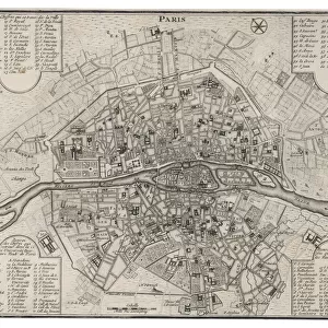
Old Map of North America 1852 by Henry George Collins

![]()
Wall Art and Photo Gifts from MapSeeker
Old Map of North America 1852 by Henry George Collins
This is a finely detailed map of North America remastered from a rare Atlas of the World published in 1852 by Henry George Collins. Although these Henry Collins produced maps of the highest quality in his time unfortunately not the same could be said in terms of his business success. His maps were later obtained by the famous Stanford Map Company and used in their publications
Welcome to the Mapseeker Image library and enter an historic gateway to one of the largest on-line collections of Historic Maps, Nostalgic Views, Vista's and Panorama's from a World gone by.
Media ID 20347273
© Mapseeker Publishing Ltd
Collins Collins Atlas Collins Atlas Map Collins Map Continental Map Old Continental Map
FEATURES IN THESE COLLECTIONS
> Arts
> Photorealistic artworks
> Detailed art pieces
> Masterful detailing in art
> Maps and Charts
> Related Images
> Maps and Charts
> World
EDITORS COMMENTS
This beautifully preserved print showcases an exquisite piece of cartographic history - the "Old Map of North America 1852" by Henry George Collins. Remastered from a rare Atlas of the World published in 1852, this map offers a fascinating glimpse into the past. Henry Collins was renowned for his exceptional craftsmanship and attention to detail, evident in every inch of this meticulously crafted map. However, despite his undeniable talent, he faced challenges when it came to business success. Fortunately, these remarkable maps found their way into the hands of the esteemed Stanford Map Company. Recognizing their value and historical significance, they incorporated them into their own publications. As we explore this old map of North America, we are transported back in time to an era when borders were different and territories were yet to be fully explored. The intricate details on this continental map allow us to trace coastlines, rivers, mountain ranges, and even settlements that have long since transformed or disappeared altogether. With its rich colors and fine lines delicately etched onto aged parchment-like paper, this print is not only a visual delight but also a testament to human curiosity and exploration. It serves as a reminder that while Henry George Collins may not have achieved commercial success during his lifetime, his legacy lives on through these extraordinary maps that continue to captivate historians and enthusiasts alike.
MADE IN THE USA
Safe Shipping with 30 Day Money Back Guarantee
FREE PERSONALISATION*
We are proud to offer a range of customisation features including Personalised Captions, Color Filters and Picture Zoom Tools
SECURE PAYMENTS
We happily accept a wide range of payment options so you can pay for the things you need in the way that is most convenient for you
* Options may vary by product and licensing agreement. Zoomed Pictures can be adjusted in the Cart.