Home > Arts > Artists > H > Jodocus Hondius
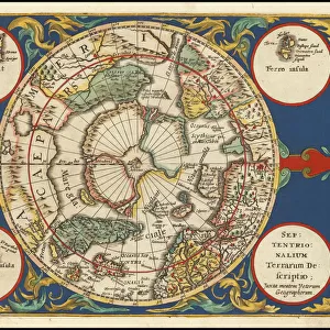
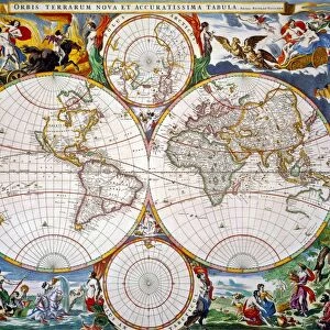
Old Map of The Americas 1635 by Willem & Johan Blaue from the Theatrum Orbis Terrarum

![]()
Wall Art and Photo Gifts from MapSeeker
Old Map of The Americas 1635 by Willem & Johan Blaue from the Theatrum Orbis Terrarum
This detailed and most attractive reproduction map of The Americas has been carefully art worked from a scan of an antique original. The famous firm of Dutch cartographers and publishers was established in the late 16th century by Willem Janszoon Blaeu in Amsterdam. Blaeu was a maker of globes and scientific instruments and purchased some of his early map plates from Jodocus Hondius. From this small beginning was to emerge one of the largest and most prolific map publishing houses of the seventeenth century
Welcome to the Mapseeker Image library and enter an historic gateway to one of the largest on-line collections of Historic Maps, Nostalgic Views, Vista's and Panorama's from a World gone by.
Media ID 20347719
Blaeu Blaeu Family Blaue Map Continental Map Historic Map Johan Blaeu Johan Blaeu Map Old Blaue Map Americas Continent
FEATURES IN THESE COLLECTIONS
> Arts
> Artists
> B
> Willem Blaeu
> Arts
> Artists
> H
> Jodocus Hondius
> Arts
> Photorealistic artworks
> Detailed art pieces
> Masterful detailing in art
> Maps and Charts
> Early Maps
> Maps and Charts
> Willem Janszoon Blaeu
EDITORS COMMENTS
This beautifully crafted reproduction of the "Old Map of The Americas 1635" by Willem & Johan Blaue takes us on a captivating journey back in time. Carefully art worked from an antique original, this detailed map showcases the rich history and exploration of the Americas during the 17th century. The renowned Dutch cartographers and publishers, Willem Janszoon Blaeu and his son Johan Blaeu, established their firm in Amsterdam. Initially specializing in globes and scientific instruments, they soon expanded to become one of the largest and most prolific map publishing houses of their time. With its intricate design and precise cartography, this historic map offers a glimpse into how early explorers perceived the continents. From North to South America, every detail is meticulously depicted – from coastlines to mountain ranges, rivers to cities. As we study this remarkable piece of history, we are transported back to an era where vast territories were yet uncharted. It serves as a reminder of the courage and curiosity that drove these adventurers across oceans in search of new lands. Whether you're a history enthusiast or simply captivated by old-world charm, this Old Map of The Americas will undoubtedly spark your imagination with its timeless beauty. Hang it proudly on your wall as a testament to human exploration or use it as inspiration for your own journeys through these fascinating continents.
MADE IN THE USA
Safe Shipping with 30 Day Money Back Guarantee
FREE PERSONALISATION*
We are proud to offer a range of customisation features including Personalised Captions, Color Filters and Picture Zoom Tools
SECURE PAYMENTS
We happily accept a wide range of payment options so you can pay for the things you need in the way that is most convenient for you
* Options may vary by product and licensing agreement. Zoomed Pictures can be adjusted in the Cart.