
Maps Collection
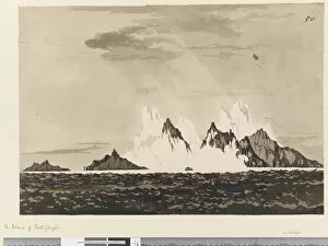
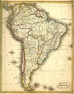
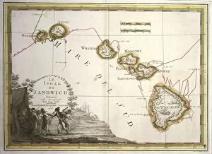
The South Georgia and South Sandwich Islands are located in the Southern Atlantic Ocean, east of Argentina and south of the Falkland Islands
Choose a picture from our Maps Collection for your Wall Art and Photo Gifts
13 items
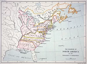
All Professionally Made to Order for Quick Shipping
-
Maps Collection
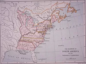
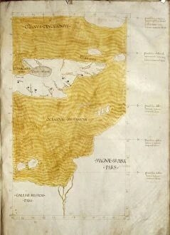
The South Georgia and South Sandwich Islands are located in the Southern Atlantic Ocean, east of Argentina and south of the Falkland Islands. The islands are part of a British Overseas Territory, administered by the United Kingdom. Maps of these islands provide detailed information about their geography, climate, flora and fauna. The main island is South Georgia which is mountainous with glaciers covering much of its land area. Other smaller islands include Bird Island, Shag Rocks and Clerke Rocks. The climate is cold and wet with temperatures rarely rising above freezing point in winter months. Wildlife includes seals, penguins and albatrosses while vegetation consists mainly of tussock grasses and shrubs such as Antarctic hair grass. There are no permanent human settlements on these remote islands but there are scientific research stations located on some of them which provide valuable data for scientific studies related to global warming and other environmental issues affecting this region.
+
Our beautiful pictures are available as Framed Prints, Photos, Wall Art and Photo Gifts
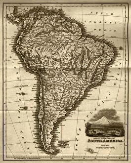
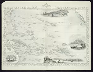
Media Storehouse offers a stunning collection of Maps of South Georgia and South Sandwich Islands, South America. Our collection features an array of high-quality wall art and framed prints that showcase the beauty and diversity of these remote islands located in the southern Atlantic Ocean. The maps depict intricate details such as coastlines, topography, settlements, and wildlife habitats. The Maps of South Georgia and South Sandwich Islands collection is perfect for anyone who loves geography or wants to add a touch of adventure to their home decor. These maps are not only visually appealing but also educational as they provide valuable information about these unique islands. Whether you're looking for a vintage-style map or a modern interpretation, Media Storehouse has something for everyone. Their selection includes various sizes and framing options to suit any taste or budget. With this impressive collection from Media Storehouse, you can bring the beauty of South Georgia and South Sandwich Islands into your home or office space.
+
What are Maps of South Georgia and South Sandwich Islands South America art prints?
Maps of South Georgia and South Sandwich Islands South America art prints are high-quality reproductions of vintage maps that depict the geography, topography, and landmarks of these remote regions. These art prints showcase the intricate details of the islands' coastlines, mountains, glaciers, and other natural features in stunningly accurate detail. These maps were originally created by explorers and cartographers who ventured into these uncharted territories during the 19th century. They provide a fascinating glimpse into how these areas were perceived at a time when much of the world was still largely unknown. Whether you're a history buff or simply appreciate beautiful artwork, Maps of South Georgia and South Sandwich Islands South America art prints make for an excellent addition to any home or office decor. We offer a unique perspective on some of the most isolated places on Earth while also serving as a testament to human curiosity and exploration.
+
What Maps of South Georgia and South Sandwich Islands South America art prints can I buy from Media Storehouse?
We offer a wide range of South Georgia and South Sandwich Islands art prints that showcase the beauty and diversity of this stunning region in South America. These maps are available in different sizes, styles, and formats to suit your preferences. You can choose from vintage-style maps that capture the history of the islands or contemporary designs that highlight their natural features. Some popular options include detailed topographical maps that show the terrain and elevation of the islands, as well as satellite images that provide a bird's eye view of their geography. There are also artistic renditions featuring colorful illustrations or abstract patterns inspired by the landscape. Whether you're looking for a unique piece to decorate your home or office, or simply want to learn more about these fascinating islands, we have something for everyone. With high-quality printing and materials, these art prints are sure to impress and inspire.
+
How do I buy Maps of South Georgia and South Sandwich Islands South America art prints?
To buy maps of South Georgia and South Sandwich Islands, as well as other South America art prints, you can visit Media Storehouse. We offer a wide selection of high-quality prints that are perfect for decorating your home or office. To purchase a print, simply browse our collection online and select the one you want to buy. Once you have chosen your print, add it to your cart and proceed to checkout. At checkout, you will be asked to provide your shipping information and payment details. After completing the transaction, Media Storehouse will process your order and ship it out to you in a timely manner. Their prints are available in various sizes and formats such as canvas or framed prints. You can choose the format that best suits your needs and preferences. Buying maps of South Georgia and South Sandwich Islands from Media Storehouse is an easy process that allows you to bring beautiful artwork into your home or office with ease.
+
How much do Maps of South Georgia and South Sandwich Islands South America art prints cost?
We offer a range of maps of South Georgia and South Sandwich Islands art prints. The cost of these prints varies depending on the size and type of print you choose. We have a variety of options available including framed or unframed prints, canvas prints, and poster prints. Our prices are competitive and reflect the quality of our products. Our maps of South Georgia and South Sandwich Islands art prints are perfect for anyone looking to add some unique artwork to their home or office decor. These stunning maps showcase the beauty and intricacies of this region in great detail, making them an excellent conversation starter. Whether you're a collector or simply looking for a beautiful piece to display in your home or office, our maps of South Georgia and South Sandwich Islands art prints are sure to impress. So why not browse our selection today?
+
How will my Maps of South Georgia and South Sandwich Islands South America art prints be delivered to me?
Your Maps of South Georgia and South Sandwich Islands South America art prints will be delivered to you through our reliable shipping partners. We take great care in packaging your artwork to ensure it arrives at your doorstep in perfect condition. Our standard delivery service includes tracking information so that you can monitor the progress of your shipment. We offer a variety of shipping options, including express delivery for urgent orders. Depending on where you are located, we may also offer local pickup options or same-day delivery services. We understand the importance of timely and secure delivery when it comes to valuable artwork. That's why we work with trusted logistics providers who have years of experience delivering fragile items like art prints. Rest assured that your Maps of South Georgia and South Sandwich Islands South America art prints will arrive safely and promptly thanks to our efficient shipping processes.