Rights Managed > Universal Images Group (UIG) > Art > Painting, Sculpture & Prints > Cartography
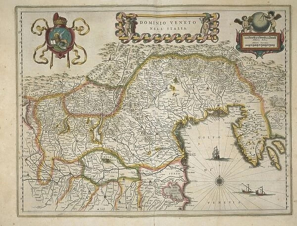
Map of Venetian domain, from Regionum Italiae by Willem Blaeu, engraving
Filename: 940_18_11285269.jpg
Size: 3450 x 2626 (4.5MB)
Date: 16th March 2014
Source: Universal Images Group (UIG)
Source: De Agostini Picture Library
© DEA PICTURE LIBRARY
![]()

Wall Art and Photo Gifts from Universal Images Group (UIG)
Map of Venetian domain, from Regionum Italiae by Willem Blaeu, engraving
Cartography, Italy, 17th century. Venetian domain. From Regionum Italiae by Willem Blaeu. Engraving
Universal Images Group (UIG) manages distribution for many leading specialist agencies worldwide
Media ID 9570579
© DEA PICTURE LIBRARY
17th Century Aerial View Angel Border Coat Of Arms Compass Connection Croatia Direction Fictional Being Guidance Nautical Vessel Navigational Equipment Sailing Ship Ship Slovenia Text Transportation Trentino Trentino Alto Adige Veneto Western Script Willem Blaeu Istria Non Urban Scene
EDITORS COMMENTS
This print showcases a stunning map of the Venetian domain, meticulously engraved by the renowned cartographer Willem Blaeu in the 17th century. The intricate details and exquisite craftsmanship of this engraving transport us back in time to an era when Italy and Croatia were connected through their shared borders and maritime routes. The map reveals a fascinating topography, with its coat of arms proudly displayed alongside texts that provide essential guidance for travelers navigating these lands. An angelic figure hovers above, symbolizing divine protection over those embarking on their journeys across this picturesque landscape. A sailing ship gracefully glides along the Adriatic Sea, representing the vital role transportation played in shaping the history of this region. From Istria to Slovenia, from Veneto to Trentino Alto Adige, this comprehensive map encompasses various territories within Europe's rich tapestry. With its horizontal orientation and aerial view perspective, one can almost imagine themselves soaring above these lands as they were centuries ago. The compass serves as a navigational tool guiding explorers through uncharted waters while adding an element of adventure to their travels. This remarkable piece of art captures not only geographical accuracy but also evokes a sense of wonderment about our past. It reminds us how cartography has long been intertwined with human curiosity and exploration—a testament to both our desire for knowledge and our ability to create beauty through engravings like those crafted by Willem Blaeu.
MADE IN THE USA
Safe Shipping with 30 Day Money Back Guarantee
FREE PERSONALISATION*
We are proud to offer a range of customisation features including Personalised Captions, Color Filters and Picture Zoom Tools
SECURE PAYMENTS
We happily accept a wide range of payment options so you can pay for the things you need in the way that is most convenient for you
* Options may vary by product and licensing agreement. Zoomed Pictures can be adjusted in the Cart.

