Canvas Print > Europe > Hungary > Maps
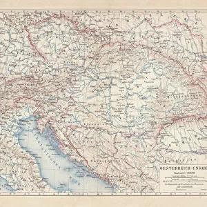
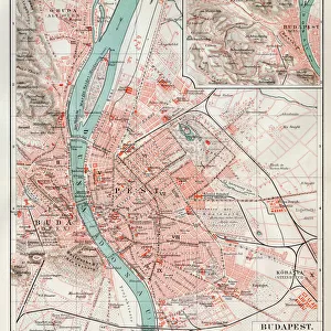
Canvas Print : Antique map of Austrian Empire, 1897, late 19th Century


![]()
Canvas Prints from Fine Art Storehouse
Antique map of Austrian Empire, 1897, late 19th Century
Vintage engraving of a Antique map of Austrian Empire, 1897, late 19th Century
Unleash your creativity and transform your space into a visual masterpiece!
duncan1890
Media ID 18206125
© of Duncan P Walker
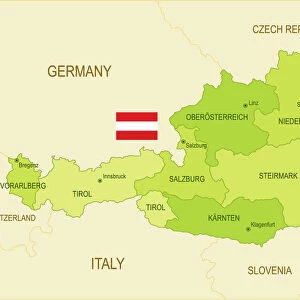
Austria Hungary Austrian Empire Austro Hungarian Empire
20"x16" (51x41cm) Canvas Print
"Step back in time with our exquisite Canvas Print of an Antique Map of the Austrian Empire, 1897. This vintage engraving, sourced from the Fine Art Storehouse and created by the talented artist duncan1890, transports you to the late 19th century. The intricate details and rich colors of this antique map are beautifully rendered on high-quality canvas, making it a stunning addition to any room in your home or office. Hang it in your study, library, or living room to add an air of sophistication and historical charm. Each Canvas Print is printed on demand and carefully crafted to ensure the highest quality and authenticity, making it a truly unique and treasured piece. Order yours today and let the stories of the past come alive in your space."
Delivered stretched and ready to hang our premium quality canvas prints are made from a polyester/cotton blend canvas and stretched over a 1.25" (32mm) kiln dried knot free wood stretcher bar. Packaged in a plastic bag and secured to a cardboard insert for safe transit.
Canvas Prints add colour, depth and texture to any space. Professionally Stretched Canvas over a hidden Wooden Box Frame and Ready to Hang
Estimated Product Size is 50.8cm x 40.6cm (20" x 16")
These are individually made so all sizes are approximate
Artwork printed orientated as per the preview above, with landscape (horizontal) orientation to match the source image.
FEATURES IN THESE COLLECTIONS
> Europe
> Austria
> Related Images
> Europe
> Hungary
> Related Images
> Maps and Charts
> Related Images
> Fine Art Storehouse
> Map
> Historical Maps
EDITORS COMMENTS
This print showcases an exquisite antique map of the Austrian Empire, dating back to 1897 during the late 19th century. Crafted with meticulous detail and precision, this vintage engraving offers a fascinating glimpse into the historical boundaries and territories of the Austro-Hungarian Empire, also known as Austria-Hungary. The map depicts a vast expanse of land that once constituted one of Europe's most influential empires. From its capital Vienna to regions stretching across Central Europe, including present-day Austria, Hungary, Czech Republic, Slovakia, Slovenia, Croatia, Bosnia and Herzegovina, parts of Italy and Romania - this empire held immense political power in its time. With delicate lines etched onto aged parchment-like paper and faded hues adding an air of nostalgia to the piece; it is evident that this print has been carefully preserved over generations. The intricate details capture not only geographical features such as rivers and mountain ranges but also major cities and towns that were significant centers within the empire. Duncan1890's masterful reproduction allows us to appreciate both the artistic beauty and historical significance encapsulated within this antique map. Whether you are a history enthusiast or simply drawn to vintage aesthetics; this print serves as a timeless reminder of an era long gone by - inviting us to explore the rich heritage embedded in our past.
MADE IN THE USA
Safe Shipping with 30 Day Money Back Guarantee
FREE PERSONALISATION*
We are proud to offer a range of customisation features including Personalised Captions, Color Filters and Picture Zoom Tools
SECURE PAYMENTS
We happily accept a wide range of payment options so you can pay for the things you need in the way that is most convenient for you
* Options may vary by product and licensing agreement. Zoomed Pictures can be adjusted in the Cart.