Canvas Print > Europe > France > Canton > Landes
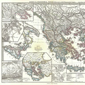
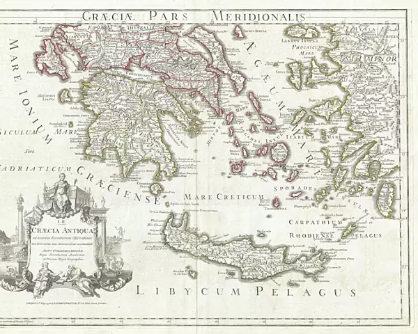
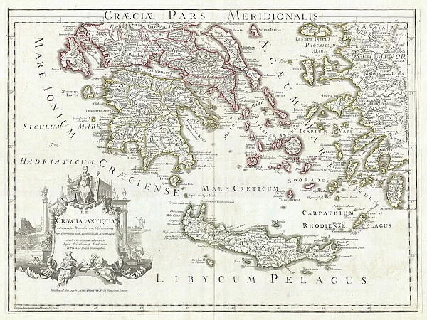
Canvas Print : 1794, Delisle Map of Southern Ancient Greece, Greeks Isles, and Crete, topography


![]()
Canvas Prints from Liszt Collection
1794, Delisle Map of Southern Ancient Greece, Greeks Isles, and Crete, topography
1794, Delisle Map of Southern Ancient Greece, Greeks Isles, and Crete
Liszt Collection of nineteenth-century engravings and images to browse and enjoy
Media ID 14004831
© Artokoloro Quint Lox Limited
1794 Antique Map Latitude Longitude Mappa Mundi Old Antique Plan Old Antique View Ols Antique Map Rare Old Maps Topo
20"x16" (51x41cm) Canvas Print
Introducing the Media Storehouse Canvas Print featuring the historic 1794 Delisle Map of Southern Ancient Greece, Greeks Isles, and Crete from the esteemed Liszt Collection. This captivating map, published over two centuries ago, provides a fascinating glimpse into the ancient world. Each detail, from the intricate topography to the meticulously rendered islands, invites exploration and discovery. Our premium canvas prints are meticulously crafted with museum-quality materials, ensuring vibrant colors and sharp details that bring history to life in your home or office. Experience the rich history of ancient Greece like never before with this stunning, large-format canvas print.
Delivered stretched and ready to hang our premium quality canvas prints are made from a polyester/cotton blend canvas and stretched over a 1.25" (32mm) kiln dried knot free wood stretcher bar. Packaged in a plastic bag and secured to a cardboard insert for safe transit.
Canvas Prints add colour, depth and texture to any space. Professionally Stretched Canvas over a hidden Wooden Box Frame and Ready to Hang
Estimated Product Size is 50.8cm x 40.6cm (20" x 16")
These are individually made so all sizes are approximate
Artwork printed orientated as per the preview above, with landscape (horizontal) orientation to match the source image.
FEATURES IN THESE COLLECTIONS
> Europe
> France
> Canton
> Landes
> Europe
> Greece
> Related Images
> Historic
> Ancient civilizations
> Ancient Greece
> Greek history
> Historic
> Space exploration
> Maps and Charts
> Early Maps
> Maps and Charts
> Related Images
> Maps and Charts
> World
EDITORS COMMENTS
This print showcases the exquisite 1794 Delisle Map of Southern Ancient Greece, Greek Isles, and Crete. A true masterpiece of cartography, this topographical map provides a detailed illustration of the region's geography and landforms. Its precise grid system based on latitude and longitude adds a touch of geometric elegance to its overall design. A vintage treasure steeped in history, this ancient map takes us on a visual journey through time. It offers an invaluable glimpse into the past, allowing us to explore the world as it was centuries ago. The delicate artistry and intricate details make it not just a navigational tool but also a decorative piece that exudes charm. Printed on aged paper with retro aesthetics, this rare antique map evokes a sense of nostalgia for bygone eras when exploration and discovery were at their peak. It serves as both an educational resource for historians and geographers alike while also serving as an artistic representation of Earth's diverse regions. The Liszt Collection has preserved this remarkable piece from oblivion so that we may appreciate its historical significance today. This print is more than just an old antique view; it is a mappa mundi that connects us to our past while reminding us of the vastness and beauty of our world.
MADE IN THE USA
Safe Shipping with 30 Day Money Back Guarantee
FREE PERSONALISATION*
We are proud to offer a range of customisation features including Personalised Captions, Color Filters and Picture Zoom Tools
SECURE PAYMENTS
We happily accept a wide range of payment options so you can pay for the things you need in the way that is most convenient for you
* Options may vary by product and licensing agreement. Zoomed Pictures can be adjusted in the Cart.