Fine Art Print > Europe > United Kingdom > England > Devon > Stonehouse
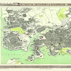
Fine Art Print : Old Map of Plymouth Devonport and Stonehouse 1851 by John Tallis


![]()
Fine Art Prints from MapSeeker
Old Map of Plymouth Devonport and Stonehouse 1851 by John Tallis
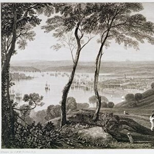
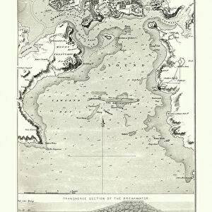
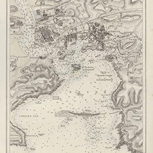
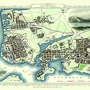
An attractive Victorian plan of Plymouth in Devon by John Tallis 1851, with Morice Town, Higher Stoke, Stoke, Devonport and Stonehouse. There are three illustrations on the plan of Plymouth, the Column, a view across Plymouth Sound and a busy scene across to Plymouth and the famous Citadel
Welcome to the Mapseeker Image library and enter an historic gateway to one of the largest on-line collections of Historic Maps, Nostalgic Views, Vista's and Panorama's from a World gone by.
Media ID 20347632
Historic Map John Tallis John Tallis Map Old Town Plan Tallis Map Devonport Plymouth Stonehouse
21"x14" (+3" Border) Fine Art Print
Step back in time with our exquisite Old Map of Plymouth Devonport and Stonehouse, a fine art print from the Media Storehouse collection. Dating back to 1851, this captivating Victorian plan of Plymouth, Devon, is an intricately detailed work of art by renowned mapmaker John Tallis. Featuring Morice Town, Higher Stoke, Stoke, Devonport, and Stonehouse, this print offers a glimpse into the history and architecture of Plymouth during the 19th century. Add a touch of historical charm to your home or office with this stunning piece of cartographic art.
21x14 image printed on 27x20 Fine Art Rag Paper with 3" (76mm) white border. Our Fine Art Prints are printed on 300gsm 100% acid free, PH neutral paper with archival properties. This printing method is used by museums and art collections to exhibit photographs and art reproductions.
Our fine art prints are high-quality prints made using a paper called Photo Rag. This 100% cotton rag fibre paper is known for its exceptional image sharpness, rich colors, and high level of detail, making it a popular choice for professional photographers and artists. Photo rag paper is our clear recommendation for a fine art paper print. If you can afford to spend more on a higher quality paper, then Photo Rag is our clear recommendation for a fine art paper print.
Estimated Image Size (if not cropped) is 53.3cm x 35.5cm (21" x 14")
Estimated Product Size is 68.6cm x 50.8cm (27" x 20")
These are individually made so all sizes are approximate
Artwork printed orientated as per the preview above, with landscape (horizontal) orientation to match the source image.
FEATURES IN THESE COLLECTIONS
> Arts
> Artists
> T
> John Tallis
> Europe
> United Kingdom
> England
> Devon
> Devonport
> Europe
> United Kingdom
> England
> Devon
> Plymouth
> Europe
> United Kingdom
> England
> Devon
> Related Images
> Europe
> United Kingdom
> England
> Devon
> Stoke
> Europe
> United Kingdom
> England
> Devon
> Stonehouse
> Popular Themes
> Devon
> MapSeeker
> British Town And City Plans
> English & Welsh PORTFOLIO
EDITORS COMMENTS
This Victorian print showcases an exquisite old map of Plymouth, Devonport, and Stonehouse in 1851. Created by the talented cartographer John Tallis, this intricate town plan offers a glimpse into the rich history of these charming English towns. The map features various notable locations such as Morice Town, Higher Stoke, Stoke, Devonport, and Stonehouse. Three stunning illustrations adorn the plan: The Column stands tall as a symbol of strength and resilience; a breathtaking view across Plymouth Sound captures the beauty of its coastal landscape; and a bustling scene depicts life in Plymouth with its famous Citadel standing proudly in the background. Transporting us back to another era, this historic map provides valuable insights into how these areas were laid out during Victorian times. It is not only a fascinating piece for collectors or enthusiasts but also serves as an educational resource for those interested in local history. Whether you are exploring your ancestry or simply appreciating the artistry behind antique maps, this print offers a unique opportunity to delve into the past and discover more about the vibrant city of Plymouth and its surrounding neighborhoods - Devonport and Stonehouse.
MADE IN THE USA
Safe Shipping with 30 Day Money Back Guarantee
FREE PERSONALISATION*
We are proud to offer a range of customisation features including Personalised Captions, Color Filters and Picture Zoom Tools
SECURE PAYMENTS
We happily accept a wide range of payment options so you can pay for the things you need in the way that is most convenient for you
* Options may vary by product and licensing agreement. Zoomed Pictures can be adjusted in the Cart.