Fine Art Print > Animals > Mammals > Muridae > Western Mouse
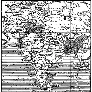
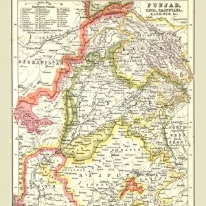
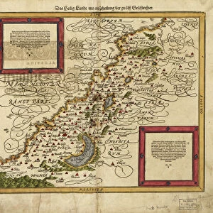
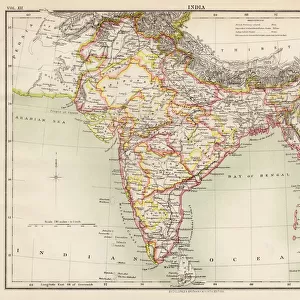
Fine Art Print : Partition. Map of East and West Punjab


![]()
Fine Art Prints from Mary Evans Picture Library
Partition. Map of East and West Punjab
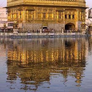
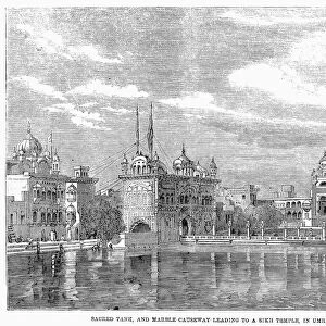
The areas of the Western and Eastern Punjab where there were many outbreaks of violence between Muslims, Sikhs and Hindus following Partition and the creation of modern India and Pakistan
Mary Evans Picture Library makes available wonderful images created for people to enjoy over the centuries
Media ID 4410760
© Mary Evans Picture Library 2015 - https://copyrighthub.org/s0/hub1/creation/maryevans/MaryEvansPictureID/10238531
1947 Creation Exodus Hindu Hindus Muslim Muslims Pakistan Partition Punjab Sikh Sikhs Violence
21"x14" (+3" Border) Fine Art Print
Step into history with our exquisite selection of Fine Art Prints from Media Storehouse, featuring the poignant and profound 'Map of East and West Punjab' by Rights Managed from Mary Evans Prints Online. This evocative image serves as a powerful reminder of the historical events surrounding the Partition of India and Pakistan in 1947. The map illustrates the areas of Western and Eastern Punjab, where intense conflict between Muslims, Sikhs, and Hindus unfolded, shaping the modern geopolitical landscape. Each print is meticulously produced using premium materials and vibrant colors, ensuring a stunning addition to your home or office decor. Relive history through the lens of this captivating art piece.
21x14 image printed on 27x20 Fine Art Rag Paper with 3" (76mm) white border. Our Fine Art Prints are printed on 300gsm 100% acid free, PH neutral paper with archival properties. This printing method is used by museums and art collections to exhibit photographs and art reproductions.
Our fine art prints are high-quality prints made using a paper called Photo Rag. This 100% cotton rag fibre paper is known for its exceptional image sharpness, rich colors, and high level of detail, making it a popular choice for professional photographers and artists. Photo rag paper is our clear recommendation for a fine art paper print. If you can afford to spend more on a higher quality paper, then Photo Rag is our clear recommendation for a fine art paper print.
Estimated Image Size (if not cropped) is 53.3cm x 35.5cm (21" x 14")
Estimated Product Size is 68.6cm x 50.8cm (27" x 20")
These are individually made so all sizes are approximate
Artwork printed orientated as per the preview above, with landscape (horizontal) orientation to match the source image.
FEATURES IN THESE COLLECTIONS
> Animals
> Mammals
> Muridae
> Western Mouse
> Asia
> India
> Related Images
> Asia
> Pakistan
> Related Images
> Maps and Charts
> Early Maps
> Maps and Charts
> India
> Maps and Charts
> Related Images
EDITORS COMMENTS
This evocative map print depicts the Eastern and Western regions of Punjab on the eve of the momentous event that would forever alter the political and demographic landscape of the Indian subcontinent. The year was 1947, and the partition of India and Pakistan was imminent. The map highlights the areas of intense violence and displacement that erupted between Muslims, Sikhs, and Hindus in the wake of this historical division. The Eastern and Western Punjab, shown in vibrant shades of red and green, were the epicenters of the chaos that ensued following the creation of modern India and Pakistan. The map serves as a stark reminder of the exodus that took place as millions of people were forced to leave their homes and cross the newly drawn borders, often facing unimaginable hardships and violence along the way. The map does not merely represent a geographical boundary but a tragic chapter in the history of the Indian subcontinent. The partition of Punjab led to the displacement of over 14 million people, making it one of the largest mass migrations in human history. The violence that erupted during this period claimed the lives of hundreds of thousands of people, leaving deep scars on the collective psyche of the region. This map print serves as a poignant reminder of the human cost of political divisions and the importance of understanding the complex historical context that shaped the modern nations of India and Pakistan. It is a testament to the resilience and determination of the people of the subcontinent, who have continued to rebuild their lives and communities in the face of adversity.
MADE IN THE USA
Safe Shipping with 30 Day Money Back Guarantee
FREE PERSONALISATION*
We are proud to offer a range of customisation features including Personalised Captions, Color Filters and Picture Zoom Tools
SECURE PAYMENTS
We happily accept a wide range of payment options so you can pay for the things you need in the way that is most convenient for you
* Options may vary by product and licensing agreement. Zoomed Pictures can be adjusted in the Cart.