Framed Print > Arts > Artists > H > James Holland
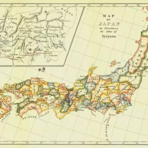
Framed Print : Map of Japan in Provinces in time of Iyeyasu, 1903. Creator: Unknown


![]()
Framed Photos from Heritage Images
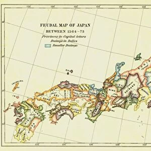
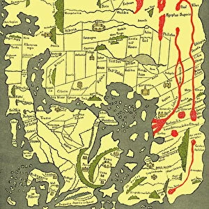
Map of Japan in Provinces in time of Iyeyasu, 1903. Creator: Unknown
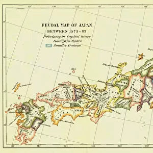
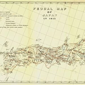
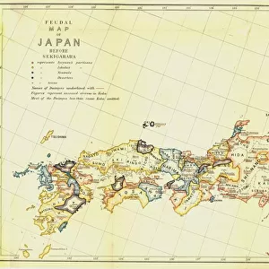
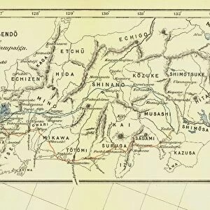
Map of Japan in Provinces in time of Iyeyasu, 1903. Tokugawa Ieyasu (1543-1616) first shogun of the Tokugawa shogunate which ruled Japan from 1600-1868 and is known as the Edo period. Leyasu chose to distance Japan from European influence, although granting trading rights to the Dutch East India Company, in 1614 he signed the Christian Expulsion Edict which banned the practice of Christianity. From A History of Japan during the century of early foreign intercourse (1542-1651) by James Murdoch, M.A. and Isoh Yamagata. [Kobe, Japan, 1903]
Heritage Images features heritage image collections
Media ID 19667033
© The Print Collector/Heritage Images
Cartography Division Dutch East India Company Edo Bakufu Government Ieyasu Ieyasu Tokugawa Island Isoh Isoh Yamagata Iyeyasu James Murdoch Map Making Murdoch Murdoch James Nikko Tosho Gu Pacific Ocean Province Tokugawa Tokugawa Bakufu Tokugawa Ieyasu Tokugawa Shogunate Yamagata Yamagata Isoh
18"x14" Modern Frame
Introducing the exquisite and enlightening addition to your home or office decor - the "Map of Japan in Provinces in time of Iyeyasu, 1903" from Media Storehouse's Framed Prints collection. This captivating vintage map transports you back in time to the Edo period of Japan (1600-1868), showcasing the intricate provinces and territories during the rule of the first shogun, Tokugawa Ieyasu (1543-1616). Crafted from the finest materials, this beautifully framed print boasts impressive detail and clarity, allowing you to explore the rich history of Japan's geography during a pivotal era. The unknown creator's masterpiece is a testament to the intricacy and artistry of the past, making it a perfect conversation starter and a meaningful investment for history enthusiasts, educators, and those who appreciate the beauty of vintage maps. Bring a touch of history, culture, and sophistication to your space with the "Map of Japan in Provinces in time of Iyeyasu, 1903" from Media Storehouse's Framed Prints collection. Order yours today and embark on a journey through time.
16x12 Print in an MDF Wooden Frame with 180 gsm Satin Finish Paper. Glazed using shatter proof thin plexiglass. Frame thickness is 1 inch and depth 0.75 inch. Fluted cardboard backing held with clips. Supplied ready to hang with sawtooth hanger and rubber bumpers. Spot clean with a damp cloth. Packaged foam wrapped in a card.
Contemporary Framed and Mounted Prints - Professionally Made and Ready to Hang
Estimated Image Size (if not cropped) is 40.6cm x 35.6cm (16" x 14")
Estimated Product Size is 45.7cm x 35.6cm (18" x 14")
These are individually made so all sizes are approximate
Artwork printed orientated as per the preview above, with landscape (horizontal) orientation to match the source image.
FEATURES IN THESE COLLECTIONS
> Arts
> Artists
> H
> James Holland
> Arts
> Artists
> O
> Oceanic Oceanic
> Asia
> East Timor
> Maps
> Asia
> East Timor
> Related Images
> Asia
> India
> Related Images
> Asia
> Japan
> Related Images
> Maps and Charts
> Early Maps
EDITORS COMMENTS
This print showcases a meticulously detailed "Map of Japan in Provinces in time of Iyeyasu" from the year 1903. Created by an unknown artist, this map takes us back to the era of Tokugawa Ieyasu, who served as the first shogun of the Tokugawa shogunate from 1600 to 1868, known as the Edo period. During his reign, Ieyasu made a conscious decision to distance Japan from European influence while still allowing trade with the Dutch East India Company. However, in 1614, he signed the Christian Expulsion Edict that prohibited Christianity within Japan. This historical document sheds light on both political and religious aspects of Japanese history during this transformative century. The map itself is a testament to exquisite cartography skills and provides valuable insights into Japan's geographical divisions at that time. It beautifully illustrates various provinces across the country and highlights important landmarks such as Nikko Toshogu Shrine and its proximity to the Pacific Ocean. Preserved through time, this rare piece offers us a glimpse into Japanese history during periods marked by significant changes in governance and foreign relations. With vibrant colors capturing our attention, it serves as an invaluable resource for scholars studying early foreign intercourse between Japan and other nations. The collaboration between James Murdoch, M. A. , and Isoh Yamagata further enhances its historical significance. As we explore this remarkable image created over a century ago in Kobe, Japan - let us appreciate not only its artistic beauty but also its ability to transport us back to an intriguing chapter in Japanese history.
MADE IN THE USA
Safe Shipping with 30 Day Money Back Guarantee
FREE PERSONALISATION*
We are proud to offer a range of customisation features including Personalised Captions, Color Filters and Picture Zoom Tools
SECURE PAYMENTS
We happily accept a wide range of payment options so you can pay for the things you need in the way that is most convenient for you
* Options may vary by product and licensing agreement. Zoomed Pictures can be adjusted in the Cart.