Framed Print > Europe > United Kingdom > England > Maps
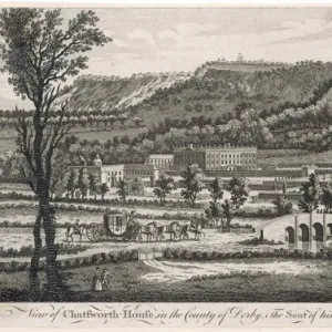
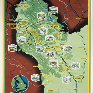
Framed Print : Map / Derbyshire C1857


![]()
Framed Photos from Mary Evans Picture Library
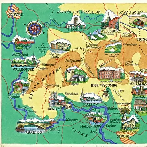
Map / Derbyshire C1857
Map of Derbyshire
Mary Evans Picture Library makes available wonderful images created for people to enjoy over the centuries
Media ID 4357693
© Mary Evans Picture Library 2015 - https://copyrighthub.org/s0/hub1/creation/maryevans/MaryEvansPictureID/10113966
12"x10" Modern Frame
Introducing the captivating "Map / Derbyshire C1857" framed print from Media Storehouse's exclusive collection. This beautiful piece, sourced from Mary Evans Prints Online, transports you back in time with its intricate details and rich history. The map, dated 1857, offers a fascinating glimpse into the geography and topography of Derbyshire during the Victorian era. Each line and contour has been carefully preserved, allowing you to explore the region's natural beauty and architectural landmarks as they once appeared. Framed in a contemporary style, this print makes a striking addition to any room, bringing a touch of history and character to your home or office. Experience the allure of the past with Media Storehouse's "Map / Derbyshire C1857" framed print.
10x8 Print in an MDF Wooden Frame with 180 gsm Satin Finish Paper. Glazed using shatter proof thin plexi glass. Frame thickness is 1 inch and depth 0.75 inch. Fluted cardboard backing held with clips. Supplied ready to hang with sawtooth hanger and rubber bumpers. Spot clean with a damp cloth. Packaged foam wrapped in a card.
Contemporary Framed and Mounted Prints - Professionally Made and Ready to Hang
Estimated Image Size (if not cropped) is 25.4cm x 25.4cm (10" x 10")
Estimated Product Size is 25.4cm x 30.5cm (10" x 12")
These are individually made so all sizes are approximate
Artwork printed orientated as per the preview above, with landscape (horizontal) or portrait (vertical) orientation to match the source image.
FEATURES IN THESE COLLECTIONS
> Europe
> United Kingdom
> England
> Derbyshire
> Related Images
> Europe
> United Kingdom
> England
> Maps
> Europe
> United Kingdom
> England
> Posters
> Maps and Charts
> Early Maps
> Maps and Charts
> Related Images
EDITORS COMMENTS
This print of a Map of Derbyshire from 1857 offers a fascinating glimpse into the historical geography of England. The intricate details and delicate craftsmanship of this map transport us back in time to the mid-19th century, allowing us to explore the landscape and boundaries of Derbyshire as they were over 150 years ago.
From its rolling hills to its charming villages, this map captures the essence of Derbyshire with precision and artistry. Each line and symbol on the map tells a story of the region's past, offering insight into how people navigated and understood their surroundings during this era.
As we study this vintage map, we are reminded of the importance of cartography in shaping our understanding of place and history. Maps like these were not only practical tools for navigation but also works of art that reflected cultural values and political boundaries.
Whether you have personal ties to Derbyshire or simply appreciate historical artifacts, this Map / Derbyshire C1857 is sure to captivate your imagination and spark your curiosity about England's rich heritage. Display it proudly in your home or office as a conversation piece that celebrates both the beauty and complexity of our world.
MADE IN THE USA
Safe Shipping with 30 Day Money Back Guarantee
FREE PERSONALISATION*
We are proud to offer a range of customisation features including Personalised Captions, Color Filters and Picture Zoom Tools
SECURE PAYMENTS
We happily accept a wide range of payment options so you can pay for the things you need in the way that is most convenient for you
* Options may vary by product and licensing agreement. Zoomed Pictures can be adjusted in the Cart.