Jigsaw Puzzle > Maps and Charts > Early Maps
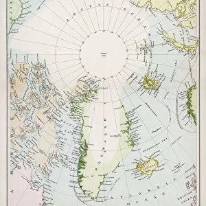
Jigsaw Puzzle : Map / Arctic Circle 1895


Jigsaw Puzzles from Mary Evans Picture Library
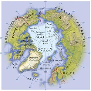
Map / Arctic Circle 1895
Map of the Arctic Circle and surrounding areas
Mary Evans Picture Library makes available wonderful images created for people to enjoy over the centuries
Media ID 608851
© Mary Evans Picture Library 2015 - https://copyrighthub.org/s0/hub1/creation/maryevans/MaryEvansPictureID/10114181
Arctic Circle Maps Surrounding 1895
Jigsaw Puzzle (520 Pieces)
Discover the thrill of piecing together history with the Media Storehouse collection of jigsaw puzzles. Our latest addition is a captivating puzzle depicting "Map / Arctic Circle 1895" from the esteemed Mary Evans Picture Library, available at Mary Evans Prints Online. This intricate puzzle showcases an antique map of the Arctic Circle and its surrounding areas, as they appeared over a century ago. Immerse yourself in the past as you meticulously place each piece, revealing the vast expanse of icy waters, explorers' routes, and territorial claims. A perfect activity for history buffs, puzzle enthusiasts, or anyone seeking a challenging and rewarding pastime. Unleash your inner explorer and embark on this intellectual adventure with the Media Storehouse Arctic Circle 1895 jigsaw puzzle.
Made in the USA, 520-piece puzzles measure 16" x 20" (40.6 x 50.8 cm). Every puzzle is meticulously printed on glossy photo paper, which has a strong 1.33 mm thickness. Delivered in a black storage cardboard box, these puzzles are both stylish and practical. (Note: puzzles contain small parts and are not suitable for children under 3 years of age.)
Jigsaw Puzzles are an ideal gift for any occasion
Estimated Product Size is 50.8cm x 40.5cm (20" x 15.9")
These are individually made so all sizes are approximate
Artwork printed orientated as per the preview above, with landscape (horizontal) or portrait (vertical) orientation to match the source image.
FEATURES IN THESE COLLECTIONS
> Maps and Charts
> Early Maps
> Maps and Charts
> Related Images
> Popular Themes
> Maps and Charts
EDITORS COMMENTS
This stunning print captures a piece of history with the Map of the Arctic Circle from 1895. The intricate details and design of this map provide a fascinating glimpse into the past, showcasing the geographical layout of the Arctic Circle and its surrounding areas during that time period.
The historical significance of this map is undeniable, as it offers valuable insights into how explorers navigated through these icy waters over a century ago. From the rugged terrain to the icy waters, every element on this map tells a story of adventure and discovery in one of Earth's most remote regions.
As we study this map closely, we can't help but marvel at the dedication and bravery of those who ventured into these uncharted territories in search of new lands and resources. The precision and accuracy with which this map was created are truly remarkable, highlighting both scientific knowledge and artistic skill.
Whether you're a history buff or simply appreciate beautiful cartography, this Map of the Arctic Circle from 1895 is sure to captivate your imagination. It serves as a reminder of our planet's vastness and diversity, urging us to explore beyond our comfort zones and embrace new horizons just waiting to be discovered.
MADE IN THE USA
Safe Shipping with 30 Day Money Back Guarantee
FREE PERSONALISATION*
We are proud to offer a range of customisation features including Personalised Captions, Color Filters and Picture Zoom Tools
SECURE PAYMENTS
We happily accept a wide range of payment options so you can pay for the things you need in the way that is most convenient for you
* Options may vary by product and licensing agreement. Zoomed Pictures can be adjusted in the Cart.