Jigsaw Puzzle > Arts > Artists > O > Oceanic Oceanic
Jigsaw Puzzle : Newfoundland, 1870s


![]()
Jigsaw Puzzles from North Wind
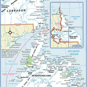
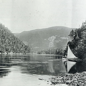
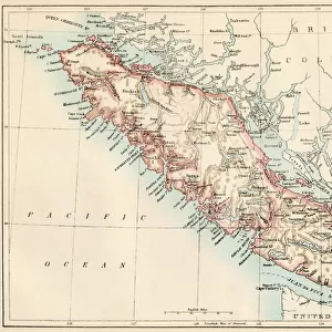
Newfoundland, 1870s
Map of Newfoundland, Canada, 1870s.
Printed color lithograph
North Wind Picture Archives brings history to life with stock images and hand-colored illustrations
Media ID 5879751
© North Wind Picture Archives
1870s Atlantic Coast Atlantic Ocean Canada Canadian Island Maritime Provinces Newfoundland Maritimes
Jigsaw Puzzle (520 Pieces)
Discover the rich history of Newfoundland with our captivating jigsaw puzzle from Media Storehouse, brought to you in partnership with North Wind Picture Archives. This intriguing puzzle features a detailed, colored lithograph of a map of Newfoundland from the 1870s. Immerse yourself in the intricacies of this fascinating piece as you journey back in time to an era of exploration and discovery. With stunning attention to detail, this puzzle is perfect for history enthusiasts, puzzle collectors, or anyone seeking a challenging and rewarding pastime. Engage your mind and bring the past to life with the Media Storehouse Newfoundland, 1870s jigsaw puzzle.
Made in the USA, 520-piece puzzles measure 16" x 20" (40.6 x 50.8 cm). Every puzzle is meticulously printed on glossy photo paper, which has a strong 1.33 mm thickness. Delivered in a black storage cardboard box, these puzzles are both stylish and practical. (Note: puzzles contain small parts and are not suitable for children under 3 years of age.)
Jigsaw Puzzles are an ideal gift for any occasion
Estimated Product Size is 40.5cm x 50.8cm (15.9" x 20")
These are individually made so all sizes are approximate
Artwork printed orientated as per the preview above, with landscape (horizontal) or portrait (vertical) orientation to match the source image.
FEATURES IN THESE COLLECTIONS
> Arts
> Artists
> O
> Oceanic Oceanic
> Maps and Charts
> Popular Maps
> Maps and Charts
> Related Images
> North America
> Canada
> Maps
> North America
> Canada
> Related Images
> Popular Themes
> North Island
> North Wind Picture Archives
> Canadian history
> North Wind Picture Archives
> Maps
EDITORS COMMENTS
This vintage print takes us back to the 1870s, offering a glimpse into the rich history and heritage of Newfoundland, Canada. The beautifully detailed map showcases this island's unique position in the Atlantic Ocean, nestled off the eastern coast of North America. With its vibrant printed colors and intricate lithograph technique, this artwork captures the essence of a bygone era. As we explore this historic illustration, we are transported to a time when Newfoundland was still an independent colony. The map highlights not only its geographical features but also provides insight into its maritime provinces and their significance within Canadian history. It serves as a reminder of how vital these coastal regions were for trade and exploration during that period. The artistry displayed in this print is truly remarkable; it evokes feelings of nostalgia while celebrating the natural beauty and cultural importance of Newfoundland. This piece offers viewers an opportunity to appreciate both the artistic talent involved in creating such maps during the 19th century and gain knowledge about historical events that shaped this region. Whether you have personal ties to Newfoundland or simply appreciate fine art with historical significance, this vintage print is sure to be treasured for years to come. Its presence on any wall will serve as a testament to our shared past and remind us of the enduring allure found within our world's diverse landscapes.
MADE IN THE USA
Safe Shipping with 30 Day Money Back Guarantee
FREE PERSONALISATION*
We are proud to offer a range of customisation features including Personalised Captions, Color Filters and Picture Zoom Tools
SECURE PAYMENTS
We happily accept a wide range of payment options so you can pay for the things you need in the way that is most convenient for you
* Options may vary by product and licensing agreement. Zoomed Pictures can be adjusted in the Cart.