Metal Print > Europe > France > Paris > Maps
Metal Print : Map / Europe / France / Paris


![]()
Metal Prints from Mary Evans Picture Library
Map / Europe / France / Paris
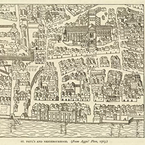
Map showing the growth of Paris from its earliest origins to the latest projects under Napoleon III
Mary Evans Picture Library makes available wonderful images created for people to enjoy over the centuries
Media ID 594576
© Mary Evans Picture Library 2015 - https://copyrighthub.org/s0/hub1/creation/maryevans/MaryEvansPictureID/10046917
1860 Earliest Growth I Ii Latest Maps Napoleon Origins Projects
16"x24" (61x41cm) Metal Print
Discover the rich history of Paris with our stunning Metal Prints from Media Storehouse, featuring this captivating map from Mary Evans Picture Library. This exquisite representation of Paris's growth from its earliest origins to the latest projects under Napoleon III takes you on a visual journey through time. Each Metal Print is meticulously crafted with vibrant colors and sharp details, ensuring your image retains its brilliance for years to come. Elevate your home or office décor with this unique and intriguing piece of art that tells a story. Order now and bring a piece of Parisian history into your space.
Made with durable metal and luxurious printing techniques, our metal photo prints go beyond traditional canvases, adding a cool, modern touch to your space. Wall mount on back. Eco-friendly 100% post-consumer recycled ChromaLuxe aluminum surface. The thickness of the print is 0.045". Featuring a Scratch-resistant surface and Rounded corners. Backing hangers are attached to the back of the print and float the print 1/2-inch off the wall when hung, the choice of hanger may vary depending on size and International orders will come with Float Mount hangers only. Finished with a brilliant white high gloss surface for unsurpassed detail and vibrance. Printed using Dye-Sublimation and for best care we recommend a non-ammonia glass cleaner, water, or isopropyl (rubbing) alcohol to prevent harming the print surface. We recommend using a clean, lint-free cloth to wipe off the print. The ultra-hard surface is scratch-resistant, waterproof and weatherproof. Avoid direct sunlight exposure.
Made with durable metal and luxurious printing techniques, metal prints bring images to life and add a modern touch to any space
Estimated Product Size is 61.5cm x 41.2cm (24.2" x 16.2")
These are individually made so all sizes are approximate
Artwork printed orientated as per the preview above, with landscape (horizontal) orientation to match the source image.
FEATURES IN THESE COLLECTIONS
> Mary Evans Prints Online
> Maps
> Europe
> France
> Paris
> Maps
> Europe
> France
> Paris
> Related Images
> Maps and Charts
> Early Maps
> Maps and Charts
> Related Images
EDITORS COMMENTS
This print from Mary Evans Picture Library showcases a detailed map of Europe, specifically focusing on the growth of Paris throughout history. From its earliest origins to the latest projects under Napoleon III in 1860, this map provides a fascinating glimpse into the historical development of one of the most iconic cities in France.
The intricate details and markings on the map offer insight into how Paris evolved over time, highlighting key landmarks and significant changes that took place under Napoleon I and II. The viewer can trace the city's expansion and transformation through various eras, gaining a deeper understanding of its rich history and cultural significance.
As we study this map, we are transported back in time to witness the evolution of Paris unfold before our eyes. It serves as a reminder of the city's resilience and adaptability, showcasing how it has continuously reinvented itself to become the vibrant metropolis we know today.
Whether you're a history buff or simply appreciate beautiful cartography, this print is sure to captivate your imagination and spark your curiosity about Paris' past. Dive into this visual journey through time with Mary Evans Prints Online and explore the fascinating story behind one of Europe's most beloved cities.
MADE IN THE USA
Safe Shipping with 30 Day Money Back Guarantee
FREE PERSONALISATION*
We are proud to offer a range of customisation features including Personalised Captions, Color Filters and Picture Zoom Tools
SECURE PAYMENTS
We happily accept a wide range of payment options so you can pay for the things you need in the way that is most convenient for you
* Options may vary by product and licensing agreement. Zoomed Pictures can be adjusted in the Cart.