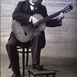
Photographic Print > Europe > United Kingdom > England > London > Politics > Arthur Wellesley
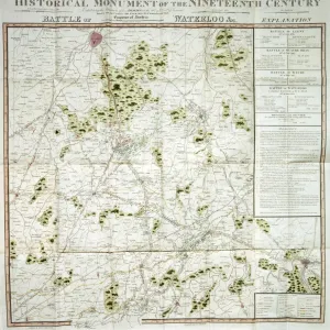
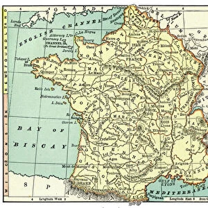
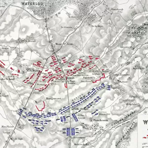
Photographic Print : Map of the Battle of Waterloo, 18th June 1815 (19th century)
")


Photo Prints from Heritage Images
Map of the Battle of Waterloo, 18th June 1815 (19th century)
Map of the Battle of Waterloo, 18th June 1815 (19th century). Battle plan showing the positions of the British and French armies at the outset of the battle
Heritage Images features heritage image collections
Media ID 15137750
© Historica Graphica Collection / Heritage-Images
1st Consul Bonaparte 1st Duke Of Wellington Arthur Arthur Wellesley Battle Of Waterloo Battle Plan Bonaparte Bonaparte General Bonaparte The Corsican Boney Brabant Duke Of Duke Of Wellington Emperor Napoleon Emperor Of France First Consul Bonaparte General Bonaparte Iron Duke Johnston Lord Wellington Napo Napoleon Napoleon 1 Napoleon 1st Napoleon Bonaparte Napoleon Bonaparte I Napoleon I Napoleon L Napoleone Di Buonaparte Napoleonic Wars Position Sir Arthur Wellesley The Iron Duke Waterloo Wellesley Wellington Alexander Keith Battlefield Historica Graphica Collection
10"x8" Photo Print
Discover the rich history of the Battle of Waterloo with our stunning photographic print from Media Storehouse, featuring this intricately detailed 19th century map of the Battle of Waterloo, 18th June 1815. Witness the strategic positions of the British and French armies as they prepared for the fateful encounter that would change the course of history. This captivating vintage map, sourced from Heritage Images, is an essential addition to any history enthusiast's collection or office decor. Bring the past to life with this captivating piece of historical art.
Photo prints are produced on Kodak professional photo paper resulting in timeless and breath-taking prints which are also ideal for framing. The colors produced are rich and vivid, with accurate blacks and pristine whites, resulting in prints that are truly timeless and magnificent. Whether you're looking to display your prints in your home, office, or gallery, our range of photographic prints are sure to impress. Dimensions refers to the size of the paper in inches.
Our Photo Prints are in a large range of sizes and are printed on Archival Quality Paper for excellent colour reproduction and longevity. They are ideal for framing (our Framed Prints use these) at a reasonable cost. Alternatives include cheaper Poster Prints and higher quality Fine Art Paper, the choice of which is largely dependant on your budget.
Estimated Image Size (if not cropped) is 25.4cm x 18.2cm (10" x 7.2")
Estimated Product Size is 25.4cm x 20.3cm (10" x 8")
These are individually made so all sizes are approximate
Artwork printed orientated as per the preview above, with landscape (horizontal) orientation to match the source image.
FEATURES IN THESE COLLECTIONS
> Europe
> Belgium
> Related Images
> Europe
> United Kingdom
> England
> London
> Politics
> Arthur Wellesley
> Europe
> United Kingdom
> Scotland
> Moray
> Keith
> Historic
> Battles
> Battle of Waterloo
> British Army
> Historic
> Battles
> Battle of Waterloo
> Duke of Wellington
> Historic
> Battles
> Battle of Waterloo
> French Army
EDITORS COMMENTS
This 19th-century print showcases a meticulously detailed "Map of the Battle of Waterloo, 18th June 1815". The battle plan vividly illustrates the initial positions of both the British and French armies as they prepared to engage in one of history's most significant conflicts. The map offers an intriguing glimpse into this pivotal moment in time, where two great military minds clashed on the fields of Belgium. On one side stands Napoleon Bonaparte, Emperor of France and renowned military strategist, known by many names such as Boney or Bonaparte the Corsican. On the other side is Arthur Wellesley, Duke of Wellington and esteemed British commander also referred to as The Iron Duke. With its vibrant colors and intricate engravings, this historic artifact transports us back to that fateful day when nations collided. It provides valuable insight into troop movements, geographical features, and strategic considerations that shaped the outcome of this monumental battle. As we examine this piece from the Historica Graphica Collection by Alexander Keith Johnston with awe-inspiring attention to detail, we are reminded not only of the immense scale but also the human cost associated with warfare. This map serves as a testament to bravery displayed by soldiers on both sides who fought valiantly for their respective countries. A true treasure for history enthusiasts and scholars alike, this remarkable print immortalizes a defining moment in European history – forever etching Waterloo into our collective memory.
MADE IN THE USA
Safe Shipping with 30 Day Money Back Guarantee
FREE PERSONALISATION*
We are proud to offer a range of customisation features including Personalised Captions, Color Filters and Picture Zoom Tools
SECURE PAYMENTS
We happily accept a wide range of payment options so you can pay for the things you need in the way that is most convenient for you
* Options may vary by product and licensing agreement. Zoomed Pictures can be adjusted in the Cart.