Home > Abstract Art > Painting > Related Images
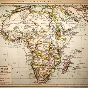
East Guinea containing the Kingdoms of Loango, Congo, Angola and Benguela, engraving by G. Zuliani taken from Tome IV of the "Newest Atlas" published in Venice in 1784 by Antonio Zatta, Private Collection

![]()
Wall Art and Photo Gifts from Fondazione Alinari per la Fotografia
East Guinea containing the Kingdoms of Loango, Congo, Angola and Benguela, engraving by G. Zuliani taken from Tome IV of the "Newest Atlas" published in Venice in 1784 by Antonio Zatta, Private Collection
East Guinea containing the Kingdoms of Loango, Congo, Angola and Benguela, engraving by G. Zuliani taken from Tome IV of the "Newest Atlas" published in Venice in 1784 by Antonio Zatta, Private Collection Florence Engraving Eighteenth Century, Renaissance-Baroque styles and periods, Europe, First and Second Millennium A.D.. Date of Photograph:2009. Date of Artwork:1784. Artist:Zuliani G
Alinari
PDP-A-ZATTA4-0018
Media ID 33187629
© Alinari Archives, Florence
Cartography Drawing And Graphics Geography Graphics Instrument And Document Scene Means Of Communication Territory Abstract Concept And Symbol Concept Or Subject Expressed
FEATURES IN THESE COLLECTIONS
> Abstract Art
> Painting
> Related Images
> Abstract Art
> Related Images
> Africa
> Angola
> Related Images
> Arts
> Abstract art
> Arts
> Art Movements
> Baroque
> Arts
> Art Movements
> Renaissance Art
> Arts
> Still life artwork
> Abstract art
> Fine art
> Arts
> Minimalist artwork
> Abstract art
> Fine art
> Arts
> Modern art pieces
> Abstract art
> Fine art
EDITORS COMMENTS
This print showcases an exquisite engraving titled "East Guinea containing the Kingdoms of Loango, Congo, Angola and Benguela". Crafted by the talented G. Zuliani in 1784, this masterpiece was published in Venice as part of Antonio Zatta's renowned "Newest Atlas". The artwork takes us on a visual journey through time and space, transporting us to the vibrant lands of East Guinea during the eighteenth century. With its intricate details and meticulous craftsmanship, it reflects both Renaissance-Baroque styles and periods prevalent in Europe at that time. As we delve into this historical gem, we are reminded of the power of cartography as a means of communication. The map serves not only as a geographical representation but also as an allegory for exploration and discovery. It symbolizes mankind's insatiable curiosity about uncharted territories. Through this engraving, Zuliani skillfully captures abstract concepts such as territory and geography while simultaneously presenting them with precision and accuracy. The artist's expertise is evident in every stroke, transforming mere lines into a vivid depiction of vast kingdoms. In our modern era where technology dominates communication methods, this artwork stands as a testament to the importance placed on maps during earlier centuries. It reminds us that before GPS or satellite imagery existed, maps were invaluable instruments for navigation and documentation. Photographed by Alinari in 2009 from their private collection in Florence, this image allows us to appreciate not only the artistry behind Zuliani's work but also its historical significance within European society during the first and second millennium A. D. Whether you are fascinated by history or drawn to beautiful aesthetics, this print offers a glimpse into an era when maps held immense value – both as practical tools for understanding our world and as works of art capable of capturing our imagination.
MADE IN THE USA
Safe Shipping with 30 Day Money Back Guarantee
FREE PERSONALISATION*
We are proud to offer a range of customisation features including Personalised Captions, Color Filters and Picture Zoom Tools
SECURE PAYMENTS
We happily accept a wide range of payment options so you can pay for the things you need in the way that is most convenient for you
* Options may vary by product and licensing agreement. Zoomed Pictures can be adjusted in the Cart.