Home > Europe > United Kingdom > England > London > Sport > Sailing
Angliae, Scotiae, et Hiberniae, sive Britannicar: Insularum descriptio (England, Scotland and Ireland, otherwise known as the British Isles), 1573 (copperplate engraving on paper)
, 1573 (copperplate engraving on paper)")
![]()
Wall Art and Photo Gifts from Fine Art Finder
Angliae, Scotiae, et Hiberniae, sive Britannicar: Insularum descriptio (England, Scotland and Ireland, otherwise known as the British Isles), 1573 (copperplate engraving on paper)
7340123 Angliae, Scotiae, et Hiberniae, sive Britannicar: Insularum descriptio (England, Scotland and Ireland, otherwise known as the British Isles), 1573 (copperplate engraving on paper) by Ortelius, Abraham (1527-98); 42x53 cm; National Maritime Museum, London, UK; (add.info.: Creator: Abraham Ortelius
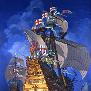
Atlas sheet from an edition of Theatrum Orbis Terrarum with Latin text, published in 1573. Hand coloured copperplate engraving. North is at 90 degrees. There is a scale, in English miles, decorated with a pair of dividers. Queen Elizabeth I's coat of arms is at top left. The title and text description are within strapwork cartouches. The sea area is decorated with a ship and three smaller sailing craft.); © National Maritime Museum, Greenwich, London
Media ID 38371920
© © National Maritime Museum, Greenwich, London / Bridgeman Images
FEATURES IN THESE COLLECTIONS
> Arts
> Artists
> O
> Abraham Ortelius
> Europe
> Republic of Ireland
> Maps
> Europe
> United Kingdom
> England
> London
> Boroughs
> Greenwich
> Europe
> United Kingdom
> England
> London
> Museums
> British Museum
> Europe
> United Kingdom
> England
> London
> Museums
> Greenwich Heritage Centre
> Europe
> United Kingdom
> England
> London
> Museums
> National Maritime Museum
> Europe
> United Kingdom
> England
> London
> Sights
> British Museum
> Europe
> United Kingdom
> England
> London
> Sport
> Sailing
> Europe
> United Kingdom
> England
> London
> Towns
> Greenwich
> Europe
> United Kingdom
> England
> Maps
> Fine Art Finder
> Artists
> Abraham Ortelius
EDITORS COMMENTS
This stunning copperplate engraving from 1573 showcases Angliae, Scotiae, et Hiberniae, sive Britannicar: Insularum descriptio (England, Scotland and Ireland), more commonly known as the British Isles. Created by the renowned cartographer Abraham Ortelius, this intricate map is a true masterpiece of 16th-century cartography.
The map features detailed depictions of England, Scotland and Ireland, with Queen Elizabeth I's coat of arms proudly displayed at the top left corner. The sea area is adorned with a ship and three smaller sailing craft, adding to the nautical theme of the piece.
Ortelius' attention to detail is evident in every aspect of this map - from the scale measured in English miles to the elaborate strapwork cartouches that frame the title and text description. The hand-colored elements bring a vibrant touch to this historical artwork, making it truly stand out among other maps from its time.
As you gaze upon this print, you can't help but marvel at the skill and artistry that went into creating such a precise representation of these iconic islands. It serves as a reminder of both our rich history and the enduring beauty of these lands we call home.
MADE IN THE USA
Safe Shipping with 30 Day Money Back Guarantee
FREE PERSONALISATION*
We are proud to offer a range of customisation features including Personalised Captions, Color Filters and Picture Zoom Tools
SECURE PAYMENTS
We happily accept a wide range of payment options so you can pay for the things you need in the way that is most convenient for you
* Options may vary by product and licensing agreement. Zoomed Pictures can be adjusted in the Cart.