Home > Europe > United Kingdom > Scotland > Edinburgh > Edinburgh
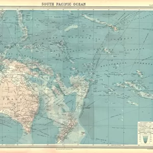
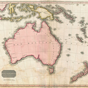
John Pinkertons map of Australia and the South West Pacific, 1818 (colour engraving)
")
![]()
Wall Art and Photo Gifts from Fine Art Finder
John Pinkertons map of Australia and the South West Pacific, 1818 (colour engraving)
696806 John Pinkertons map of Australia and the South West Pacific, 1818 (colour engraving) by Pinkerton, E. J. (fl.1844); Private Collection; (add.info.: John Pinkerton (1758-1826) was one of the leading masters of the Edinburgh school of cartography which flourished from roughly 1800 to 1830. Pinkerton & his contemporaries (Thomson & Cary) redefined European cartography by abandoning typical 18th century decorative elements such as elaborate title cartouches and fantastical beasts in favor of detail and accuracy.); Prismatic Pictures; American, out of copyright
Media ID 22409986
© Prismatic Pictures / Bridgeman Images
Borneo Cancer Capricorn Cartographer Cartography Detailed Fiji Indonesia Islands New Caledonia New Hebrides New Zealand Papua New Guinea Solomon Islands Tasmania Tropic Tropics Vanuatu
FEATURES IN THESE COLLECTIONS
> Arts
> Artists
> Related Images
> Arts
> Contemporary art
> Arts
> Photorealistic artworks
> Detailed art pieces
> Masterful detailing in art
> Arts
> Pop art
> Contemporary art
> Contemporary art gallery
> Arts
> Pop art
> Contemporary art
> Fine art gallery
> Europe
> United Kingdom
> Scotland
> Edinburgh
> Edinburgh
> Europe
> United Kingdom
> Scotland
> Lothian
> Edinburgh
> Fine Art Finder
> Artists
> Aglaüs Bouvenne
> Fine Art Finder
> Maps (celestial & Terrestrial)
EDITORS COMMENTS
This print showcases John Pinkerton's remarkable map of Australia and the South West Pacific, created in 1818. The colour engraving beautifully captures the intricate details and accuracy that defined Pinkerton's work as one of the leading masters of the Edinburgh school of cartography. Pinkerton, along with his contemporaries Thomson and Cary, revolutionized European cartography by departing from traditional decorative elements and focusing on precision. This shift can be seen in this particular map, where elaborate title cartouches and fantastical beasts are replaced by a meticulous depiction of the region. The map encompasses a vast area, including Fiji, Papua New Guinea, Borneo, Indonesia, Solomon Islands, New Zealand, Tasmania, Vanuatu (formerly known as New Hebrides), New Caledonia, and more. It provides an invaluable resource for understanding the geography of these regions during that time period. Notably absent are exaggerated depictions often found in earlier maps; instead Pinkerton prioritizes accuracy to provide a reliable representation. This attention to detail is evident throughout every inch of this engraving. As we gaze upon this historic piece of cartographic artistry captured through Prismatic Pictures' lens for Bridgeman Images' collection - we are transported back to a time when exploration was at its peak. The map serves as both a testament to Pinkerton's skill as a cartographer and an intriguing window into our past.
MADE IN THE USA
Safe Shipping with 30 Day Money Back Guarantee
FREE PERSONALISATION*
We are proud to offer a range of customisation features including Personalised Captions, Color Filters and Picture Zoom Tools
SECURE PAYMENTS
We happily accept a wide range of payment options so you can pay for the things you need in the way that is most convenient for you
* Options may vary by product and licensing agreement. Zoomed Pictures can be adjusted in the Cart.