Home > Aerial Photography > France
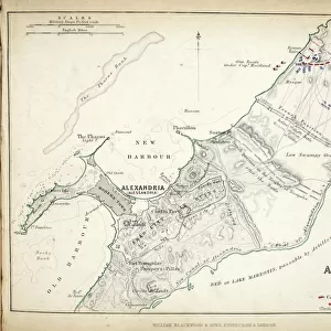
Map of the Battle of Fere Champenoise and the Battle of Arcis-Sur-Aube

![]()
Wall Art and Photo Gifts from Fine Art Finder
Map of the Battle of Fere Champenoise and the Battle of Arcis-Sur-Aube
746878 Map of the Battle of Fere Champenoise and the Battle of Arcis-Sur-Aube, published by William Blackwood and Sons, Edinburgh & London, 1848 (hand-coloured engraving) by Johnston, Alexander Keith (1804-71); Private Collection; (add.info.: Battle of FAre-Champenoise (25 March 1814). Battle of Arcis-sur-Aube (20-21 March 1814)); The Stapleton Collection; Scottish, out of copyright
Media ID 22424804
© The Stapleton Collection / Bridgeman Images
Aerial View Armies Mapping Positions War Of The Sixth Coalition Prussia Prussian
FEATURES IN THESE COLLECTIONS
> Aerial Photography
> Related Images
> Aerial Photography
> Scotland
> Arts
> Artists
> A
> William Alexander
> Arts
> Artists
> K
> William Keith
> Europe
> France
> Canton
> Aube
> Europe
> Russia
> Aerial Views
> Fine Art Finder
> Artists
> Alexander Keith Johnston
> Fine Art Finder
> Maps (celestial & Terrestrial)
EDITORS COMMENTS
This hand-coloured engraving, titled "Map of the Battle of Fere Champenoise and the Battle of Arcis-Sur-Aube" takes us back to a significant moment in history. Published by William Blackwood and Sons in 1848, this piece showcases the exceptional cartographic skills of Alexander Keith Johnston. The map depicts two crucial battles from the War of the Sixth Coalition: The Battle of Fere Champenoise on March 25th, 1814, and the Battle of Arcis-sur-Aube on March 20th-21st, 1814. Through its aerial view perspective, we gain insight into the strategic positions held by French, Russian, and Prussian armies during these conflicts. With meticulous detail and precision characteristic of Johnston's work, this engraving allows us to immerse ourselves in a pivotal moment where nations clashed for dominance. It serves as a testament to both military prowess and historical significance. As we observe this remarkable print from the Private Collection within The Stapleton Collection archives, it becomes evident that maps are not merely tools for navigation but also windows into our past. This particular piece offers an invaluable glimpse into nineteenth-century mapping techniques while preserving an essential chapter in European history. Let us appreciate this extraordinary artwork for its historical value as well as its artistic merit—an enduring reminder that even amidst chaos and conflict lies beauty waiting to be discovered.
MADE IN THE USA
Safe Shipping with 30 Day Money Back Guarantee
FREE PERSONALISATION*
We are proud to offer a range of customisation features including Personalised Captions, Color Filters and Picture Zoom Tools
SECURE PAYMENTS
We happily accept a wide range of payment options so you can pay for the things you need in the way that is most convenient for you
* Options may vary by product and licensing agreement. Zoomed Pictures can be adjusted in the Cart.