Home > Europe > France > Canton > Cote d Or
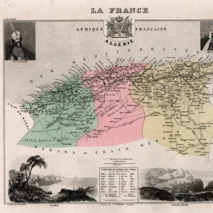
Department of the Cote d Or (21) in Burgundy - France and its Colonies. Atlas illustrates one hundred and five maps from the maps of the depot of war, bridges and footwear and the Navy by M. VUILLEMIN. 1876
 in Burgundy - France and its Colonies. Atlas illustrates one hundred and five maps from the maps of the depot of war, bridges and footwear and the Navy by M. VUILLEMIN. 1876")
![]()
Wall Art and Photo Gifts from Fine Art Finder
Department of the Cote d Or (21) in Burgundy - France and its Colonies. Atlas illustrates one hundred and five maps from the maps of the depot of war, bridges and footwear and the Navy by M. VUILLEMIN. 1876
XEE4144603 Department of the Cote d Or (21) in Burgundy - France and its Colonies. Atlas illustrates one hundred and five maps from the maps of the depot of war, bridges and footwear and the Navy by M. VUILLEMIN. 1876. by Vuillemin, Alexandre (1812-1886); Private Collection; (add.info.: Department of the Cote d Or (21) in Burgundy - France and its Colonies. Atlas illustrates one hundred and five maps from the maps of the depot of war, bridges and footwear and the Navy by M. VUILLEMIN. 1876.); Stefano Bianchetti; French, out of copyright
Media ID 25153714
© Stefano Bianchetti / Bridgeman Images
Atlas Book Burgundy Gold Cote 21 Geographical Map
FEATURES IN THESE COLLECTIONS
> Europe
> France
> Canton
> Cote d Or
> Fine Art Finder
> Artists
> Alexandre Vuillemin
> Maps and Charts
> Related Images
> Services
> Royal Navy
EDITORS COMMENTS
This print showcases a historical atlas titled "Department of the Cote d Or (21) in Burgundy - France and its Colonies". Created by Alexandre Vuillemin in 1876, this remarkable piece features one hundred and five meticulously detailed maps sourced from various military depots, bridges, footwear departments, and the Navy. The atlas provides an extensive geographical overview of the region with a particular focus on Burgundy - France and its colonies. The enchanting engraving captures the essence of this extraordinary work, highlighting its vibrant colors and intricate details. The map itself is a testament to Vuillemin's expertise as it beautifully depicts the Department of Cote d'Or (21), situated in picturesque Burgundy - France. This region holds immense historical significance due to its rich cultural heritage and breathtaking landscapes. Stefano Bianchetti skillfully captured this timeless piece for posterity, allowing us to appreciate not only the artistic beauty but also gain insights into French geography during that era. As we delve into each map within this splendid atlas book, we are transported back in time to witness how these regions were perceived over a century ago. This print serves as both an educational resource for geography enthusiasts and a stunning visual representation of history. It offers viewers an opportunity to explore the intricacies of French cartography while appreciating Vuillemin's exceptional craftsmanship.
MADE IN THE USA
Safe Shipping with 30 Day Money Back Guarantee
FREE PERSONALISATION*
We are proud to offer a range of customisation features including Personalised Captions, Color Filters and Picture Zoom Tools
SECURE PAYMENTS
We happily accept a wide range of payment options so you can pay for the things you need in the way that is most convenient for you
* Options may vary by product and licensing agreement. Zoomed Pictures can be adjusted in the Cart.