Home > Europe > France > Canton > Lozere
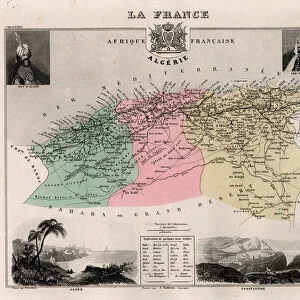
La Lozere (48), Languedoc-Roussillon (Languedoc Roussillon) - France and its Colonies. Atlas illustrates one hundred and five maps drawn from the maps of the depot of war, bridges and footwear and the Navy by M. VUILLEMIN. 1876
, Languedoc-Roussillon (Languedoc Roussillon) - France and its Colonies. Atlas illustrates one hundred and five maps drawn from the maps of the depot of war, bridges and footwear and the Navy by M. VUILLEMIN. 1876")
![]()
Wall Art and Photo Gifts from Fine Art Finder
La Lozere (48), Languedoc-Roussillon (Languedoc Roussillon) - France and its Colonies. Atlas illustrates one hundred and five maps drawn from the maps of the depot of war, bridges and footwear and the Navy by M. VUILLEMIN. 1876
XEE4144518 La Lozere (48), Languedoc-Roussillon (Languedoc Roussillon) - France and its Colonies. Atlas illustrates one hundred and five maps drawn from the maps of the depot of war, bridges and footwear and the Navy by M. VUILLEMIN. 1876. by Vuillemin, Alexandre (1812-1886); Private Collection; (add.info.: La Lozere (48), Languedoc-Roussillon (Languedoc Roussillon) - France and its Colonies. Atlas illustrates one hundred and five maps drawn from the maps of the depot of war, bridges and footwear and the Navy by M. VUILLEMIN. 1876.); Stefano Bianchetti; French, out of copyright
Media ID 25164274
© Stefano Bianchetti / Bridgeman Images
Atlas Book Languedoc Roussillon Loz And Xe8 Lozere 48 Re 48 Geographical Map
FEATURES IN THESE COLLECTIONS
> Europe
> France
> Canton
> Lozere
> Fine Art Finder
> Artists
> Alexandre Vuillemin
> Maps and Charts
> Related Images
> Services
> Royal Navy
EDITORS COMMENTS
This print showcases a historical atlas titled "La Lozere (48), Languedoc-Roussillon (Languedoc Roussillon) - France and its Colonies". Published in 1876, the atlas features one hundred and five meticulously drawn maps derived from various sources such as the depot of war, bridges and footwear, and the Navy by M. VUILLEMIN. The artist behind this remarkable work is Alexandre Vuillemin (1812-1886), whose talent shines through each map presented in this collection. The intricate details and precise cartography provide a glimpse into the geographical landscape of France during that era. Stefano Bianchetti has beautifully captured this engraving on a geographic map, showcasing his skill as a photographer. The vibrant colors bring life to the image, allowing viewers to appreciate both the artistry of Vuillemin's maps and Bianchetti's photographic expertise. This particular map focuses on La Lozere (48) within the region of Languedoc-Roussillon in southern France. It offers insights into not only the topography but also provides valuable information about French colonies during that time period. As we gaze upon this photograph print, we are transported back to 19th-century France, marveling at how these maps were once essential tools for navigation and exploration. This piece serves as a testament to both historical significance and artistic brilliance, making it an invaluable addition to any collection or display dedicated to geography enthusiasts or
MADE IN THE USA
Safe Shipping with 30 Day Money Back Guarantee
FREE PERSONALISATION*
We are proud to offer a range of customisation features including Personalised Captions, Color Filters and Picture Zoom Tools
SECURE PAYMENTS
We happily accept a wide range of payment options so you can pay for the things you need in the way that is most convenient for you
* Options may vary by product and licensing agreement. Zoomed Pictures can be adjusted in the Cart.