Home > Europe > France > Canton > Lot
General Map of the whole of Europe, divided into its main countries

![]()
Wall Art and Photo Gifts from Fine Art Finder
General Map of the whole of Europe, divided into its main countries
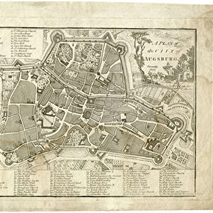
986324 General Map of the whole of Europe, divided into its main countries, 1782 (hand-coloured engraving.) by German School, (18th century); 109x132 cm; Private Collection; (add.info.: General Map of the whole of Europe, divided into its main countries; Carte Generale de toute L Europe, divise selon l etendue de ses principaux etats, by Mathias Albrecht Lotter (1741-1810). German School, (18th century). Hand-coloured engraving. Published in Augsburg by Tobie Conrad Lotter, 1782. 109 x 132cm.); Photo eChristies Images; German, out of copyright
Media ID 23293088
© Christie's Images / Bridgeman Images
1780s 1782 Artist German Cartographer Divided French Text Geographic German Art German Artist German School Green Colour Hand Colored Hand Coloring Hand Coloured Hand Colouring Hand Tinted Handcolored Language Late 18th Century Late Eighteenth Century Lettering Navigational Equipment Old Masters Prints Profession Western Europe Word Yellow Lotter
FEATURES IN THESE COLLECTIONS
> Animals
> Mammals
> Muridae
> Western Mouse
> Europe
> France
> Canton
> Lot
> Europe
> Germany
> Related Images
> Fine Art Finder
> Artists
> Alexis-Hubert Jaillot
> Fine Art Finder
> Artists
> German School
> Fine Art Finder
> Temp Classification
EDITORS COMMENTS
This print showcases a remarkable piece of art titled "General Map of the whole of Europe, divided into its main countries". Created by the German School in the 18th century, this hand-coloured engraving offers a comprehensive depiction of Europe during that time. Measuring 109x132 cm, it is an impressive testament to the skill and precision of Mathias Albrecht Lotter (1741-1810), who was responsible for its creation. The vibrant colours used in this map bring each country to life, with shades of yellow, green, and pink highlighting their distinct borders. The intricate lettering adds further detail and navigational information throughout the artwork. This late eighteenth-century masterpiece captures both the artistic prowess and geographic knowledge prevalent during that era. As we explore this close-up view of the map, we are transported back in time to witness Europe as it once was. With no people present in the image, our focus remains solely on appreciating the craftsmanship behind this extraordinary work. The hand-colouring technique employed here enhances every aspect of this cartographic marvel. This photograph from Fine Art Finder allows us to appreciate not only European geography but also German artistry at its finest. It serves as a reminder that maps can be more than just functional tools; they can also be works of art capable of capturing historical moments with breathtaking beauty.
MADE IN THE USA
Safe Shipping with 30 Day Money Back Guarantee
FREE PERSONALISATION*
We are proud to offer a range of customisation features including Personalised Captions, Color Filters and Picture Zoom Tools
SECURE PAYMENTS
We happily accept a wide range of payment options so you can pay for the things you need in the way that is most convenient for you
* Options may vary by product and licensing agreement. Zoomed Pictures can be adjusted in the Cart.