Home > Asia > Saudi Arabia > Maps
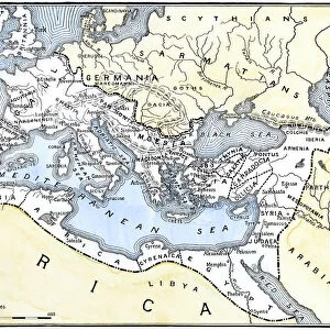
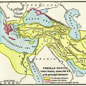
Map of ancient Babylon and the kingdoms of Lydia and Medea (Asia Minor), around 550 BC. There are: Arab countries, Armenia, Mesopotamia, Babylon, Thraces, Europe, the Mediterranean Sea, Egypt and North Africa. Colouring engraving of the 19th century
, around 550 BC. There are: Arab countries, Armenia, Mesopotamia, Babylon, Thraces, Europe, the Mediterranean Sea, Egypt and North Africa. Colouring engraving of the 19th century")
![]()
Wall Art and Photo Gifts from Fine Art Finder
Map of ancient Babylon and the kingdoms of Lydia and Medea (Asia Minor), around 550 BC. There are: Arab countries, Armenia, Mesopotamia, Babylon, Thraces, Europe, the Mediterranean Sea, Egypt and North Africa. Colouring engraving of the 19th century
NWI4859781 Map of ancient Babylon and the kingdoms of Lydia and Medea (Asia Minor), around 550 BC. There are: Arab countries, Armenia, Mesopotamia, Babylon, Thraces, Europe, the Mediterranean Sea, Egypt and North Africa. Colouring engraving of the 19th century.; (add.info.: Map of ancient Babylon and the kingdoms of Lydia and Medea (Asia Minor), around 550 BC. There are: Arab countries, Armenia, Mesopotamia, Babylon, Thraces, Europe, the Mediterranean Sea, Egypt and North Africa. Colouring engraving of the 19th century.); Photo © North Wind Pictures
Media ID 38479670
© © North Wind Pictures / Bridgeman Images
Armenia Armenian Babylon Iraq Iraq Iraqi Iraqi Mediterranean Sea Mesopotamia Saudi Arabia Arab Civilization Arab Culture Arabians Egyptians Geographical Map
FEATURES IN THESE COLLECTIONS
> Africa
> Egypt
> Related Images
> Asia
> Armenia
> Related Images
> Asia
> Iraq
> Related Images
> Asia
> Saudi Arabia
> Maps
> Asia
> Saudi Arabia
> Related Images
> Fine Art Finder
> Artists
> Artist Unknown
EDITORS COMMENTS
This stunning 19th-century engraving captures the intricate details of a map showcasing ancient Babylon and the kingdoms of Lydia and Medea in Asia Minor around 550 BC. The vibrant colors bring to life the various regions depicted, from Arab countries to Armenia, Mesopotamia to Thraces, Europe to Egypt and North Africa.
As you study this historical map, you can't help but marvel at the level of detail and precision that went into its creation. Each kingdom is clearly delineated, with borders carefully outlined and labeled for easy identification. The Mediterranean Sea serves as a striking backdrop, connecting these ancient civilizations in a way that highlights their interconnectedness.
From the bustling city of Babylon to the vast deserts of Arabia, this map offers a glimpse into a bygone era when empires rose and fell with remarkable speed. It's a reminder of the rich tapestry of human history that has unfolded over millennia in this region.
Whether you're a history buff or simply appreciate fine artistry, this print is sure to captivate your imagination and transport you back in time to an age when mighty kingdoms ruled the land. Let yourself get lost in the beauty and complexity of this ancient world brought to life through color engraving.
MADE IN THE USA
Safe Shipping with 30 Day Money Back Guarantee
FREE PERSONALISATION*
We are proud to offer a range of customisation features including Personalised Captions, Color Filters and Picture Zoom Tools
SECURE PAYMENTS
We happily accept a wide range of payment options so you can pay for the things you need in the way that is most convenient for you
* Options may vary by product and licensing agreement. Zoomed Pictures can be adjusted in the Cart.