Home > Historic > Ancient civilizations > Roman Empire > Roman emperors
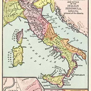
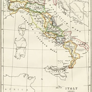
Map of Greece and Italy from Constantine I the Great to the sack of Rome during the migration period, 410) Engraving from Houze's "Atlas Universale", 1851 (engraving)
 Engraving from Houze's 'Atlas Universale', 1851 (engraving)")
![]()
Wall Art and Photo Gifts from Fine Art Finder
Map of Greece and Italy from Constantine I the Great to the sack of Rome during the migration period, 410) Engraving from Houze's "Atlas Universale", 1851 (engraving)
ELD4928075 Map of Greece and Italy from Constantine I the Great to the sack of Rome during the migration period, 410) Engraving from Houze's "Atlas Universale", 1851 (engraving); Private Collection; (add.info.: Map of Greece and Italy from Constantine I the Great to the sack of Rome during the migration period, 410)); Photo © The Holbarn Archive
Media ID 38170196
© © The Holbarn Archive / Bridgeman Images
4 4th Iv Ivth Century 4th 4th 4th Iv Iv 4th Century 4th Century 5 5th V Vth Century 5th 5th 5th V Vth Th Century 5th Century C4th C5th Constantine I Constantine The Great Emperors Fourth Century Ivth Century Roman Civilisation Vth Century Antic Rome Geographical Map Grece Greece Greek Isadora
FEATURES IN THESE COLLECTIONS
> Arts
> Artists
> R
> Roman Roman
> Europe
> Greece
> Related Images
> Europe
> Italy
> Lazio
> Rome
> Fine Art Finder
> Artists
> Artist Unknown
> Historic
> Ancient civilizations
> Ancient Greece
> Greek history
> Historic
> Ancient civilizations
> Roman Empire
> Ancient Rome
> Historic
> Ancient civilizations
> Roman Empire
> Roman art
> Historic
> Ancient civilizations
> Roman Empire
> Roman emperors
EDITORS COMMENTS
This stunning engraving from Houze's "Atlas Universale" depicts a detailed map of Greece and Italy from the reign of Constantine I the Great to the sack of Rome during the migration period in 410. The intricate lines and symbols on this map offer a glimpse into the ancient world, showcasing the vast territories controlled by emperors, including Constantine himself.
As you study this piece, you can almost feel yourself stepping back in time to an era of great power and upheaval. From the bustling streets of ancient Rome to the picturesque landscapes of Greece, every inch of this map tells a story of conquest, trade, and cultural exchange.
The Roman Empire's influence is clearly visible on this map, with its reach extending far beyond Italy into regions that are now part of modern-day Europe. It serves as a reminder of how interconnected civilizations were even centuries ago.
Whether you're a history buff or simply appreciate fine art, this print is sure to captivate your imagination and transport you to a bygone era. Let it serve as a window into the past and inspire curiosity about our shared human heritage.
MADE IN THE USA
Safe Shipping with 30 Day Money Back Guarantee
FREE PERSONALISATION*
We are proud to offer a range of customisation features including Personalised Captions, Color Filters and Picture Zoom Tools
SECURE PAYMENTS
We happily accept a wide range of payment options so you can pay for the things you need in the way that is most convenient for you
* Options may vary by product and licensing agreement. Zoomed Pictures can be adjusted in the Cart.