Home > Asia > Lebanon > Lebanon Heritage Sites > Tyre
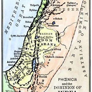
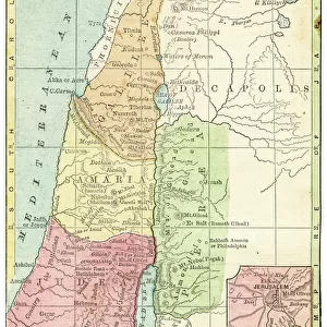
Map of Phenicia and the Kingdom of Judee under King Solomon, 10th century BC (Old Testament). The following territories are represented: Holy Land, Palestine, Gaza Strip, Lebanon, Syria, Phenicia, Tyre, Sidon and Israel
. The following territories are represented: Holy Land, Palestine, Gaza Strip, Lebanon, Syria, Phenicia, Tyre, Sidon and Israel")
![]()
Wall Art and Photo Gifts from Fine Art Finder
Map of Phenicia and the Kingdom of Judee under King Solomon, 10th century BC (Old Testament). The following territories are represented: Holy Land, Palestine, Gaza Strip, Lebanon, Syria, Phenicia, Tyre, Sidon and Israel
NWI4856509 Map of Phenicia and the Kingdom of Judee under King Solomon, 10th century BC (Old Testament). The following territories are represented: Holy Land, Palestine, Gaza Strip, Lebanon, Syria, Phenicia, Tyre, Sidon and Israel. Colour engraving of the 19th century.; (add.info.: Map of Phenicia and the Kingdom of Judee under King Solomon, 10th century BC (Old Testament). The following territories are represented: Holy Land, Palestine, Gaza Strip, Lebanon, Syria, Phenicia, Tyre, Sidon and Israel. Colour engraving of the 19th century.); Photo © North Wind Pictures
Media ID 38266538
© Photo © North Wind Pictures / Bridgeman Images
Geographical Map Israel Israeli Lebanese Lebanon Lebanon Lebanese Libanese Palestine Palestinian Phenicy Solomon ( 972 932) Solomon ( 972 932) Syria
FEATURES IN THESE COLLECTIONS
> Arts
> Artists
> S
> Syrian Syrian
> Asia
> Israel
> Related Images
> Asia
> Lebanon
> Lebanon Heritage Sites
> Tyre
> Asia
> Lebanon
> Related Images
> Asia
> Palestine
> Related Images
> Fine Art Finder
> Artists
> Artist Unknown
EDITORS COMMENTS
This stunning 19th-century color engraving depicts a map of Phenicia and the Kingdom of Judee under King Solomon in the 10th century BC, as described in the Old Testament. The territories represented on this intricate map include the Holy Land, Palestine, Gaza Strip, Lebanon, Syria, Phenicia, Tyre, Sidon and Israel.
The detailed craftsmanship of this engraving brings to life the ancient geography of these regions during King Solomon's reign. Each line and symbol tells a story of trade routes, political boundaries and cultural exchange that shaped the history of this area.
As we gaze upon this historical artifact, we are transported back in time to an era when kings ruled with wisdom and prosperity flourished throughout these lands. The legacy of King Solomon is captured in every inch of this map - from his legendary wealth to his alliances with neighboring kingdoms.
Let us marvel at the beauty and complexity of this ancient world preserved in print for us to study and appreciate. It serves as a reminder of our shared heritage and interconnected past that continues to influence our present day.
MADE IN THE USA
Safe Shipping with 30 Day Money Back Guarantee
FREE PERSONALISATION*
We are proud to offer a range of customisation features including Personalised Captions, Color Filters and Picture Zoom Tools
SECURE PAYMENTS
We happily accept a wide range of payment options so you can pay for the things you need in the way that is most convenient for you
* Options may vary by product and licensing agreement. Zoomed Pictures can be adjusted in the Cart.