Home > Europe > United Kingdom > England > London > Museums > National Maritime Museum
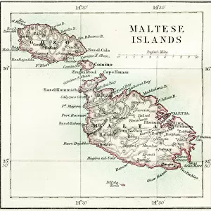
Map of Malta, Gozo and Comino, 1707 (coloured engraving)
")
![]()
Wall Art and Photo Gifts from Fine Art Finder
Map of Malta, Gozo and Comino, 1707 (coloured engraving)
7339536 Map of Malta, Gozo and Comino, 1707 (coloured engraving) by Wit, Frederick de (1630-1706); 46x57 cm; National Maritime Museum, London, UK; (add.info.: Creator: Frederik de Wit); © National Maritime Museum, Greenwich, London
Media ID 38509964
© © National Maritime Museum, Greenwich, London / Bridgeman Images
FEATURES IN THESE COLLECTIONS
> Arts
> Artists
> W
> Frederick de Wit
> Europe
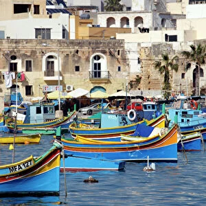
> Malta
> Related Images
> Europe
> United Kingdom
> England
> London
> Boroughs
> Greenwich
> Europe
> United Kingdom
> England
> London
> Museums
> Greenwich Heritage Centre
> Europe
> United Kingdom
> England
> London
> Museums
> National Maritime Museum
> Europe
> United Kingdom
> England
> London
> Towns
> Greenwich
> Europe
> United Kingdom
> Heritage Sites
> Maritime Greenwich
> Europe
> United Kingdom
> Maps
> Fine Art Finder
> Artists
> Frederick de Wit
EDITORS COMMENTS
This beautifully detailed coloured engraving from 1707 depicts a map of Malta, Gozo, and Comino, created by the talented cartographer Frederik de Wit. The intricate lines and vibrant colours bring to life the geography of these Mediterranean islands in the early 18th century.
The map showcases not only the physical features of the islands but also provides insight into their historical significance as part of European history. It serves as a window into a time when cartography was both an art form and a practical tool for navigation and exploration.
As you study this print, you can imagine sailors using similar maps to navigate treacherous waters or military strategists planning campaigns on these strategically located islands. The attention to detail in every corner of this map is a testament to de Wit's skill as an engraver and his dedication to accurately representing the world around him.
Whether you have a personal connection to Malta or simply appreciate historical cartography, this print is sure to capture your imagination and transport you back in time. Display it proudly in your home or office as a conversation piece that will spark curiosity and admiration for centuries-old craftsmanship.
MADE IN THE USA
Safe Shipping with 30 Day Money Back Guarantee
FREE PERSONALISATION*
We are proud to offer a range of customisation features including Personalised Captions, Color Filters and Picture Zoom Tools
SECURE PAYMENTS
We happily accept a wide range of payment options so you can pay for the things you need in the way that is most convenient for you
* Options may vary by product and licensing agreement. Zoomed Pictures can be adjusted in the Cart.