Home > Europe > United Kingdom > England > London > Museums > National Maritime Museum
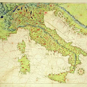
Chart of Corfu and adjacent mainland, c.1420 (Vellum)
")
![]()
Wall Art and Photo Gifts from Fine Art Finder
Chart of Corfu and adjacent mainland, c.1420 (Vellum)
7339619 Chart of Corfu and adjacent mainland, c.1420 (Vellum) by Buondelmonti, Cristoforo (1385-1430); 25x18 cm; National Maritime Museum, London, UK; (add.info.: Creator: Cristoforo Buondelmonti
There are no so scales and the orientation varies on this 15th century chart which also shows Kerkira. It's from the Book of the Islands (isolario) of the Archipelago. It covers the Ionian Islands, Aegean Islands and Constantinople.); © National Maritime Museum, Greenwich, London
Media ID 38339718
© © National Maritime Museum, Greenwich, London / Bridgeman Images
Corfu 15th 15 Xv Xvth Fifteenth Century Geographer Greece Greek
FEATURES IN THESE COLLECTIONS
> Europe
> Greece
> Related Images
> Europe
> United Kingdom
> England
> London
> Boroughs
> Greenwich
> Europe
> United Kingdom
> England
> London
> Museums
> Greenwich Heritage Centre
> Europe
> United Kingdom
> England
> London
> Museums
> National Maritime Museum
> Europe
> United Kingdom
> England
> London
> Towns
> Greenwich
> Europe
> United Kingdom
> Heritage Sites
> Maritime Greenwich
> Europe
> United Kingdom
> Maps
> Fine Art Finder
> Artists
> Battista Agnese
> Fine Art Finder
> Artists
> Cristoforo Buondelmonti
> Historic
> Ancient civilizations
> Ancient Greece
> Greek history
EDITORS COMMENTS
This stunning 15th century chart of Corfu and the adjacent mainland, created by Cristoforo Buondelmonti, is a true masterpiece of historical cartography. The intricate details and vibrant colors bring to life the beauty and complexity of this region in the medieval era.
The lack of scales and varying orientation on the map add an element of mystery, inviting viewers to explore and interpret its contents. From Kerkira to Constantinople, this chart covers a vast expanse of territory including the Ionian Islands and Aegean Islands, providing a glimpse into the geographical knowledge of the time.
Displayed in exquisite detail on vellum, this print from the Book of the Islands (isolario) of the Archipelago is a testament to Buondelmonti's skill as a geographer and artist. The precision with which he captured coastlines, rivers, and mountains showcases his dedication to accuracy in mapping.
As you gaze upon this piece at the National Maritime Museum in London, you can't help but be transported back in time to an era when exploration was at its peak. The Chart of Corfu is not just a map; it's a work of art that tells a story of discovery and adventure in centuries past.
MADE IN THE USA
Safe Shipping with 30 Day Money Back Guarantee
FREE PERSONALISATION*
We are proud to offer a range of customisation features including Personalised Captions, Color Filters and Picture Zoom Tools
SECURE PAYMENTS
We happily accept a wide range of payment options so you can pay for the things you need in the way that is most convenient for you
* Options may vary by product and licensing agreement. Zoomed Pictures can be adjusted in the Cart.