Home > Arts > Artists > H > Thomas Hand
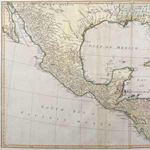
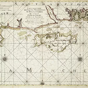
A map of the most inhabited part of New England, containing the provinces of Massachusetts Bay and New Hampshire with the colonies of Connecticut and Rhode Island, 1774 (paper)
")
![]()
Wall Art and Photo Gifts from Fine Art Finder
A map of the most inhabited part of New England, containing the provinces of Massachusetts Bay and New Hampshire with the colonies of Connecticut and Rhode Island, 1774 (paper)
7339414 A map of the most inhabited part of New England, containing the provinces of Massachusetts Bay and New Hampshire with the colonies of Connecticut and Rhode Island, 1774 (paper) by Jefferys, Thomas (c.1719-71); 53x100 cm; National Maritime Museum, London, UK; (add.info.: Creator: Thomas Jefferys
Two sheets. Hand coloured engraving. Medium: Each sheet is 2 leaves joined at centre line. Scale: [circa 1:400 000 (lat)]. Cartographic Note: Graduated. London meridian, longitude from Ferro also marked. No soundings. Shoals and sandbanks shown. Scales in English marine leagues and English miles. Additional Places: New York, Connecticut, Massachusetts, Maine. Contents Note: South sheet has title cartouche depicting the landing of the pilgrim fathers and an inset: A plan of Boston harbour (with soundings) [circa 1:150 000 (bar)]. Maps 12 & 13 from Jefferys American Atlas, published posthumously by Sayer & Bennett in 1776.); © National Maritime Museum, Greenwich, London
Media ID 38412644
© © National Maritime Museum, Greenwich, London / Bridgeman Images
Connecticut Hampshire Maine Rhode Island
FEATURES IN THESE COLLECTIONS
> Arts
> Artists
> H
> Thomas Hand
> Arts
> Artists
> J
> Thomas Jefferys
> Arts
> Artists
> N
> Thomas North
> Europe
> France
> Canton
> Maine
> Europe
> Republic of Ireland
> Maps
> Europe
> United Kingdom
> England
> Hampshire
> Related Images
> Europe
> United Kingdom
> England
> Hampshire
> Sheet
> Europe
> United Kingdom
> England
> London
> Boroughs
> Greenwich
> Europe
> United Kingdom
> England
> London
> Museums
> British Museum
> Europe
> United Kingdom
> England
> London
> Museums
> Greenwich Heritage Centre
> Fine Art Finder
> Artists
> British School
> Fine Art Finder
> Artists
> Thomas Jefferys
EDITORS COMMENTS
This stunning vintage map print showcases the most inhabited part of New England in 1774, featuring the provinces of Massachusetts Bay and New Hampshire, along with the colonies of Connecticut and Rhode Island. Created by Thomas Jefferys, a renowned cartographer from the 18th century, this intricate piece measures 53x100 cm and is housed at the National Maritime Museum in London.
The map is rich in detail, with hand-colored engravings highlighting important geographical features such as shoals, sandbanks, and soundings. It also includes scales in English marine leagues and miles for reference. The South sheet boasts a title cartouche depicting the landing of the pilgrim fathers, adding a touch of historical significance to this already fascinating artwork.
In addition to showcasing New England's landscape, this map also includes insets like "A plan of Boston harbor" with soundings for further exploration. Published posthumously by Sayer & Bennett in 1776 as part of Jefferys' American Atlas, this print offers a glimpse into colonial America during a pivotal period in history.
Whether you're a history buff or simply appreciate fine cartography, this map print is sure to captivate viewers with its beauty and historical significance. Display it proudly in your home or office to add a touch of old-world charm to any space.
MADE IN THE USA
Safe Shipping with 30 Day Money Back Guarantee
FREE PERSONALISATION*
We are proud to offer a range of customisation features including Personalised Captions, Color Filters and Picture Zoom Tools
SECURE PAYMENTS
We happily accept a wide range of payment options so you can pay for the things you need in the way that is most convenient for you
* Options may vary by product and licensing agreement. Zoomed Pictures can be adjusted in the Cart.