Home > Asia > Iran > Maps
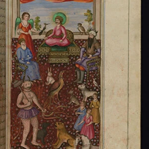
Map showing the coming of the Seljuks, 11th century. (print)
")
![]()
Wall Art and Photo Gifts from Fine Art Finder
Map showing the coming of the Seljuks, 11th century. (print)
7420047 Map showing the coming of the Seljuks, 11th century. (print); (add.info.: Map showing the coming of the Seljuks, 11th century. From the book Outline of History by H.G. Wells, published 1920.); Photo © Ken Welsh. All rights reserved 2024
Media ID 38510178
© © Ken Welsh. All rights reserved 2024 / Bridgeman Images
11 11th 11th Xi 11th 11th Century 11 11th Xi Xith Century 11 Century 11th Century Ageing C11th Chart Diagram Eleventh Century Graph Iran Iranian Iranians Persia Persians Run Down Sec Xi Xi Century Xith Century Geographer
FEATURES IN THESE COLLECTIONS
> Asia
> Iran
> Related Images
> Fine Art Finder
> Artists
> British School
> Maps and Charts
> Early Maps
EDITORS COMMENTS
This print depicts a map showing the arrival of the Seljuks in the 11th century, a pivotal moment in history captured with intricate detail. The lines and symbols on this aged map tell the story of conquest and expansion, as the Seljuk Turks made their mark on the Middle East.
Published in H.G. Wells' "Outline of History" in 1920, this print is a testament to the enduring legacy of ancient cartography. The faded edges and worn appearance only add to its charm, giving us a glimpse into centuries past.
The Seljuks were known for their military prowess and cultural achievements, shaping the landscape of Iran and beyond. This map serves as a visual representation of their influence during this tumultuous period.
As we study each line and notation on this historical artifact, we are transported back in time to witness the rise of an empire that would leave an indelible mark on world history. From Persia to Anatolia, every inch of land marked on this map tells a story waiting to be discovered.
Ken Welsh's expert reproduction captures every nuance of this ancient map, allowing us to appreciate its beauty and significance for years to come. It is not just a piece of art but also a window into our shared human history.
MADE IN THE USA
Safe Shipping with 30 Day Money Back Guarantee
FREE PERSONALISATION*
We are proud to offer a range of customisation features including Personalised Captions, Color Filters and Picture Zoom Tools
SECURE PAYMENTS
We happily accept a wide range of payment options so you can pay for the things you need in the way that is most convenient for you
* Options may vary by product and licensing agreement. Zoomed Pictures can be adjusted in the Cart.