Home > Europe > United Kingdom > England > London > Museums > National Maritime Museum
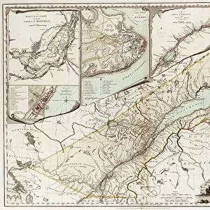
A new and correct map of the world (section), c.1774 (coloured engraving)
, c.1774 (coloured engraving)")
![]()
Wall Art and Photo Gifts from Fine Art Finder
A new and correct map of the world (section), c.1774 (coloured engraving)
7339474 A new and correct map of the world (section), c.1774 (coloured engraving) by Sayer & Bennett (18th century); 46x44 cm; National Maritime Museum, London, UK; (add.info.: Creator: Sayer & Bennett
This map was published after Captain James Cook's first voyage, and probably after the publication of Hawkesworth's Account of it in 1773, and before the results of Cook's second voyage (1772-1775) were known.); © National Maritime Museum, Greenwich, London
Media ID 38176968
© © National Maritime Museum, Greenwich, London / Bridgeman Images
FEATURES IN THESE COLLECTIONS
> Arts
> Artists
> S
> James Sayers
> Europe
> United Kingdom
> England
> London
> Boroughs
> Greenwich
> Europe
> United Kingdom
> England
> London
> Museums
> Greenwich Heritage Centre
> Europe
> United Kingdom
> England
> London
> Museums
> National Maritime Museum
> Europe
> United Kingdom
> England
> London
> Towns
> Greenwich
> Europe
> United Kingdom
> Heritage Sites
> Maritime Greenwich
> Europe
> United Kingdom
> Maps
> Fine Art Finder
> Artists
> British School
> Fine Art Finder
> Artists
> Sayer & Bennett
> Maps and Charts
> Early Maps
> Maps and Charts
> Related Images
> Maps and Charts
> World
EDITORS COMMENTS
This stunning coloured engraving from the 18th century, titled "A new and correct map of the world (section), c.1774," offers a glimpse into the cartographic knowledge of that era. Created by Sayer & Bennett, this map was published after Captain James Cook's groundbreaking first voyage and likely before the results of his second voyage were known.
The intricate details on this map showcase the artistry and precision of the geographer and engraver behind it. The black-and-white design adds a classic touch to this historical piece, making it a timeless addition to any collection.
As you study this map, you can almost feel yourself transported back in time to an age when exploration and discovery shaped our understanding of the world. The lines and symbols on this map tell stories of distant lands, unknown territories, and uncharted seas waiting to be explored.
Whether you're a history buff, a geography enthusiast, or simply appreciate fine art, this print is sure to captivate your imagination. Display it proudly in your home or office as a conversation starter and a reminder of humanity's endless quest for knowledge and adventure.
MADE IN THE USA
Safe Shipping with 30 Day Money Back Guarantee
FREE PERSONALISATION*
We are proud to offer a range of customisation features including Personalised Captions, Color Filters and Picture Zoom Tools
SECURE PAYMENTS
We happily accept a wide range of payment options so you can pay for the things you need in the way that is most convenient for you
* Options may vary by product and licensing agreement. Zoomed Pictures can be adjusted in the Cart.