Home > Europe > United Kingdom > Wales > Maps
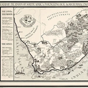
A Map of England and Wales, 1928 (colour litho)
")
![]()
Wall Art and Photo Gifts from Fine Art Finder
A Map of England and Wales, 1928 (colour litho)
1198396 A Map of England and Wales, 1928 (colour litho) by Gill, Leslie MacDonald (Max) (1884-1947); 102x153 cm; Private Collection; (add.info.: Gill, MacDonald (Max) (1884-1947)); Photo © Christies Images
Media ID 25147058
© Christie's Images / Bridgeman Images
1928 Armorial Capital Letter Classic Coats Of Arms Collectibles Collector Crest Document Documentation English Art English Artist English Text Fishing Industry Geographic Gill Green Colour Incopyright Information Label Land Language Large Group Large Group Of Objects Leslie Macdonald Gill Lettering List Lithographic Lithoprint Macdonald Gill Max Gill Navigational Equipment Patterned Printed Prints Striped Stripes Stripey Water Transport Water Vehicle Water Vessel Word Artist British British Artist Natural Space To Fish
FEATURES IN THESE COLLECTIONS
> Animals
> Fishes
> G
> Grouper
> Animals
> Fishes
> Related Images
> Animals
> Mammals
> Muridae
> Water Mouse
> Europe
> France
> Canton
> Landes
> Europe
> United Kingdom
> England
> Maps
> Europe
> United Kingdom
> Maps
> Europe
> United Kingdom
> Related Images
> Europe
> United Kingdom
> Wales
> Maps
> Europe
> United Kingdom
> Wales
> Posters
> Europe
> United Kingdom
> Wales
> Related Images
> Fine Art Finder
> Artists
> Leslie MacDonald (1884-1947) Gill
EDITORS COMMENTS
This vibrant and detailed print captures "A Map of England and Wales, 1928" by Leslie MacDonald Gill, also known as Max Gill. Measuring an impressive 102x153 cm, this colorful lithograph showcases the artist's exceptional talent in cartography. The map itself is a visual feast for the eyes, with its intricate illustrations and meticulous attention to detail. It features a close-up view of the English coastline, complete with charming depictions of ships sailing on the sea. The land is adorned with coats of arms representing different regions, adding a touch of historical significance to the artwork. Gill's skillful use of lettering and labeling enhances the informative aspect of this piece. Each town and city is clearly marked, making it not only visually appealing but also highly functional as a navigational tool. The green color palette dominates this composition, creating a sense of harmony between land and sea. The patterned stripes add depth and texture to the overall design while maintaining a cohesive aesthetic. As you explore this map closer, you can't help but appreciate Gill's artistic vision and his ability to seamlessly blend artistry with practicality. This stunning print would make an excellent addition to any collector's repertoire or serve as an educational resource for those interested in British geography or history.
MADE IN THE USA
Safe Shipping with 30 Day Money Back Guarantee
FREE PERSONALISATION*
We are proud to offer a range of customisation features including Personalised Captions, Color Filters and Picture Zoom Tools
SECURE PAYMENTS
We happily accept a wide range of payment options so you can pay for the things you need in the way that is most convenient for you
* Options may vary by product and licensing agreement. Zoomed Pictures can be adjusted in the Cart.