Home > Arts > Artists > B > Theodore de Bry
Map of 1590 engraved by Theodore de Bry after watercolour by the English colonist John White, governor of Roanoke. Virginia and coast with small islands and Roanoke at mouth of river. Secotan and Weapemeoc native lands

![]()
Wall Art and Photo Gifts from Fine Art Finder
Map of 1590 engraved by Theodore de Bry after watercolour by the English colonist John White, governor of Roanoke. Virginia and coast with small islands and Roanoke at mouth of river. Secotan and Weapemeoc native lands
528389 Map of 1590 engraved by Theodore de Bry after watercolour by the English colonist John White, governor of Roanoke. Virginia and coast with small islands and Roanoke at mouth of river. Secotan and Weapemeoc native lands. by Bry, Theodor de (1528-98); Universal History Archive/UIG
Media ID 28651555
© Universal History Archive/UIG / Bridgeman Images
1590 Bry Theodore De 1528 98 Coast Line Colonist Governor Islands John Lands Mouth Roanoke Small Theodore Theodore De Bry Virginia Secotan
FEATURES IN THESE COLLECTIONS
> Arts
> Artists
> B
> Theodor de Bry
> Arts
> Artists
> B
> Theodore de Bry
> Arts
> Artists
> W
> John White
> Fine Art Finder
> Artists
> Charles & Fontaine Pierre (1762-1853)
> Fine Art Finder
> Artists
> Theodor de Bry
> Fine Art Finder
> Temp Classification
> Maps and Charts
> Italy
EDITORS COMMENTS
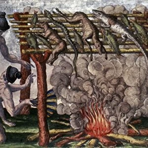
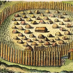
This print showcases a historic map from 1590, engraved by Theodore de Bry after a watercolor painting by the English colonist John White. The map depicts the Virginia coast and its small islands, with Roanoke situated at the mouth of a river. It also highlights the native lands of Secotan and Weapemeoc. The intricate details of this artwork transport us back to a time when exploration and colonization were shaping the world as we know it today. Governor John White's artistic talent is evident in his original watercolor, which captures both the beauty and geographical accuracy of this region. Theodore de Bry's engraving skillfully brings White's vision to life, enhancing every line and contour with meticulous precision. This collaboration between an English colonist and a German engraver exemplifies how art can bridge cultures and preserve history for generations to come. As we study this map, we are reminded of the complex interactions between European settlers and Native American tribes during this period. The inclusion of Secotan and Weapemeoc native lands serves as a reminder that these indigenous communities played an integral role in shaping early American history. Overall, this print offers not only an aesthetically pleasing depiction but also invites us to delve into centuries-old narratives that continue to shape our understanding of colonial America.
MADE IN THE USA
Safe Shipping with 30 Day Money Back Guarantee
FREE PERSONALISATION*
We are proud to offer a range of customisation features including Personalised Captions, Color Filters and Picture Zoom Tools
SECURE PAYMENTS
We happily accept a wide range of payment options so you can pay for the things you need in the way that is most convenient for you
* Options may vary by product and licensing agreement. Zoomed Pictures can be adjusted in the Cart.