Home > Animals > Mammals > Cats (Wild) > Populator
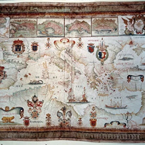
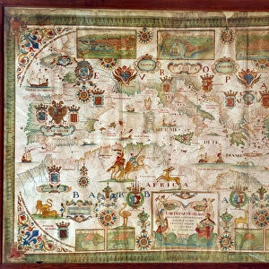
Geographic map of the Mediterranean Sea showing the coasts of Europe (France, Spain, Italy and Africa (Tunisia, Algeria, Egypt). The sea is populated with monsters and caravels
. The sea is populated with monsters and caravels")
![]()
Wall Art and Photo Gifts from Fine Art Finder
Geographic map of the Mediterranean Sea showing the coasts of Europe (France, Spain, Italy and Africa (Tunisia, Algeria, Egypt). The sea is populated with monsters and caravels
JLJ4656950 Geographic map of the Mediterranean Sea showing the coasts of Europe (France, Spain, Italy and Africa (Tunisia, Algeria, Egypt). The sea is populated with monsters and caravels, while on the land are visible all kinds of animals and inhabitants of the regions). Map of Francois Ollive, 1646. Paris, Musee de la Marine by Ollive, Francois (active 1646-1662); Musee de la Marine, Paris, France; (add.info.: Geographic map of the Mediterranean Sea showing the coasts of Europe (France, Spain, Italy and Africa (Tunisia, Algeria, Egypt). The sea is populated with monsters and caravels, while on the land are visible all kinds of animals and inhabitants of the regions). Map of Francois Ollive, 1646. Paris, Musee de la Marine); Photo © Photo Josse
Media ID 25154062
© Josse / Bridgeman Images
Maghrebin Maghrebine Mediterranean Sea Seicento Geographical Map Maghreb
FEATURES IN THESE COLLECTIONS
> Africa
> Algeria
> Related Images
> Africa
> Egypt
> Related Images
> Africa
> Related Images
> Africa
> Tunisia
> Related Images
> Animals
> Mammals
> Cats (Wild)
> Populator
> Europe
> France
> Canton
> Landes
> Fine Art Finder
> Artists
> Francois Ollive
EDITORS COMMENTS
This print showcases a geographic map of the Mediterranean Sea, providing a glimpse into the coasts of Europe and Africa during the 17th century. Created by Francois Ollive in 1646, this intricate artwork is housed in the Musee de la Marine in Paris, France. The map depicts not only the familiar coastlines of countries such as France, Spain, Italy, Tunisia, Algeria, and Egypt but also offers a fantastical twist. The sea itself is teeming with mythical monsters and majestic caravels sailing through its waters. On land, one can observe an array of animals and inhabitants from these regions. With its rich details and vibrant colors, this piece transports viewers back to an era when cartography was still evolving. It serves as a testament to both artistic skill and geographical knowledge prevalent during that time period. As we explore this remarkable image captured by Photo Josse for Fine Art Finder, we are reminded of how art has always been intertwined with our understanding of the world around us. This particular photograph allows us to appreciate not only historical accuracy but also imaginative interpretations that bring maps to life.
MADE IN THE USA
Safe Shipping with 30 Day Money Back Guarantee
FREE PERSONALISATION*
We are proud to offer a range of customisation features including Personalised Captions, Color Filters and Picture Zoom Tools
SECURE PAYMENTS
We happily accept a wide range of payment options so you can pay for the things you need in the way that is most convenient for you
* Options may vary by product and licensing agreement. Zoomed Pictures can be adjusted in the Cart.