Home > Aerial Photography > Austria
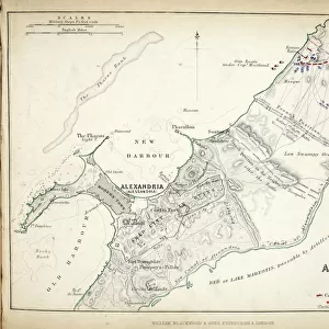
Map of the Battle of Hohenlinden, published by William Blackwood and Sons

![]()
Wall Art and Photo Gifts from Fine Art Finder
Map of the Battle of Hohenlinden, published by William Blackwood and Sons
746919 Map of the Battle of Hohenlinden, published by William Blackwood and Sons, Edinburgh & London, 1848 (hand-coloured engraving) by Johnston, Alexander Keith (1804-71); Private Collection; (add.info.: Battle of Hohenlinden (3 December 1800)
); The Stapleton Collection; Scottish, out of copyright
Media ID 23477456
© The Stapleton Collection / Bridgeman Images
Aerial View Armies French Revolutionary Wars Mapping Positions War Of The Second Coalition
FEATURES IN THESE COLLECTIONS
> Aerial Photography
> Austria
> Aerial Photography
> Related Images
> Aerial Photography
> Scotland
> Arts
> Artists
> A
> William Alexander
> Arts
> Artists
> K
> William Keith
> Europe
> Austria
> Aerial Views
> Europe
> Austria
> Related Images
> Fine Art Finder
> Artists
> Alexander Keith Johnston
> Fine Art Finder
> Artists
> Edouard Clerievanse
> Fine Art Finder
> Maps (celestial & Terrestrial)
EDITORS COMMENTS
This print showcases a hand-coloured engraving of the "Map of the Battle of Hohenlinden" published by William Blackwood and Sons in Edinburgh & London in 1848. The artist behind this remarkable piece is Alexander Keith Johnston, whose talent for cartography shines through in this intricate work. The Battle of Hohenlinden, which took place on 3 December 1800, was a significant event during the French Revolutionary Wars and War of the Second Coalition. This aerial view map provides an insightful glimpse into the positions and movements of both Austrian and French armies during this historic battle. The attention to detail in this engraving is truly impressive, allowing viewers to immerse themselves in the strategic planning that unfolded on that fateful day. As one explores each line and contour carefully etched onto paper, it becomes evident how crucial accurate mapping was for military operations during this era. This particular print hails from The Stapleton Collection, serving as a testament to Scotland's rich historical legacy. Preserved meticulously over time, it now resides within a private collection where its beauty can be appreciated by all who encounter it. As we gaze upon this exquisite map engraving from Bridgeman Images' Fine Art Finder collection, we are reminded not only of the artistry involved but also of the profound impact that war had on shaping our world centuries ago.
MADE IN THE USA
Safe Shipping with 30 Day Money Back Guarantee
FREE PERSONALISATION*
We are proud to offer a range of customisation features including Personalised Captions, Color Filters and Picture Zoom Tools
SECURE PAYMENTS
We happily accept a wide range of payment options so you can pay for the things you need in the way that is most convenient for you
* Options may vary by product and licensing agreement. Zoomed Pictures can be adjusted in the Cart.