Home > Historic > Ancient civilizations > Roman Empire > Ancient Rome
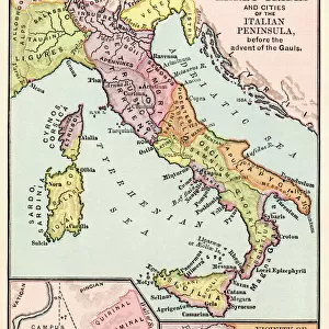
Map showing the Roman Empire and the Barbarians, 1936

![]()
Wall Art and Photo Gifts from Fine Art Finder
Map showing the Roman Empire and the Barbarians, 1936
7125144 Map showing the Roman Empire and the Barbarians, 1936; (add.info.: Map showing the Roman Empire and the Barbarians. From A Short History of the World, published c.1936); Photo © Ken Welsh. All rights reserved 2024
Media ID 38369656
© © Ken Welsh. All rights reserved 2024 / Bridgeman Images
5 5th V Vth Century 5th 5th 5th V Vth Th Century 5th Century Ageing Barbarian C5th Franks Roman Civilisation Run Down Visigoth Visigoths Vth Century Antic Rome Geographer
FEATURES IN THESE COLLECTIONS
> Arts
> Artists
> R
> Roman Roman
> Europe
> Italy
> Lazio
> Rome
> Fine Art Finder
> Artists
> Emanuel Bowen
> Historic
> Ancient civilizations
> Roman Empire
> Ancient Rome
> Historic
> Ancient civilizations
> Roman Empire
> Roman art
> Maps and Charts
> Early Maps
> Maps and Charts
> Related Images
> Maps and Charts
> World
EDITORS COMMENTS
This print showcases a map dating back to 1936, depicting the Roman Empire and the Barbarians. The intricate details of this aged cartography piece transport us back in time to an era of conquests, conflicts, and cultural exchanges.
As we gaze upon this historical artifact, we are reminded of the once mighty Roman Empire and its interactions with various barbarian tribes across Europe. The Franks, Visigoths, and other groups are highlighted on the map, each playing a significant role in shaping the course of history during the 5th century.
The engravings on this map speak volumes about the ancient world - from the grandeur of Rome to the fierce battles between civilizations. It serves as a visual representation of a bygone era filled with intrigue and power struggles.
Despite its age and weariness, this map exudes a sense of timeless beauty and importance. It is a testament to human ingenuity in mapping out territories and understanding geographical boundaries long before modern technology came into play.
In studying this piece of artistry by Ken Welsh, we gain valuable insights into our past and appreciate how far we have come as societies. Let us cherish such relics that connect us to our roots and inspire us to learn more about our shared heritage.
MADE IN THE USA
Safe Shipping with 30 Day Money Back Guarantee
FREE PERSONALISATION*
We are proud to offer a range of customisation features including Personalised Captions, Color Filters and Picture Zoom Tools
SECURE PAYMENTS
We happily accept a wide range of payment options so you can pay for the things you need in the way that is most convenient for you
* Options may vary by product and licensing agreement. Zoomed Pictures can be adjusted in the Cart.