Home > Africa > Algeria > Maps
Map of French colonial Africa, 1930 (print)
")
![]()
Wall Art and Photo Gifts from Fine Art Finder
Map of French colonial Africa, 1930 (print)
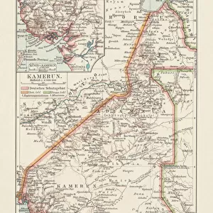
8672352 Map of French colonial Africa, 1930 (print); Private Collection; (add.info.: Map of French colonial Africa (French colonial empire) in 1930, with occupation dates from before 1871 until 1914: Western and Equatorial Africa, Morocco, Algeria, Tunisia (Maghreb - Sahara), Senegal, Sudan, Ivory Coast, Upper Volta, Guinea, Togo, Dahomey, Gabon, Cameroon, Congo, Niger, Mauritania, Chad, etc. - colonies, possessions and protectorates of France. Map drawn up by Major Pollacchi in 1930.); © Patrice Cartier. All rights reserved 2023
Media ID 38409412
© © Patrice Cartier. All rights reserved 2024 / Bridgeman Images
Carte Couleur Geographie Impression Geographer
FEATURES IN THESE COLLECTIONS
> Africa
> Algeria
> Related Images
> Africa
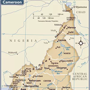
> Cameroon
> Related Images
> Africa
> Chad
> Related Images
> Africa
> Equatorial Guinea
> Maps
> Africa
> Equatorial Guinea
> Related Images
> Africa
> Gabon
> Related Images
> Fine Art Finder
> Artists
> English Photographer
EDITORS COMMENTS
This stunning print captures a detailed Map of French colonial Africa from 1930, showcasing the vast territories and regions under French rule during that time. The map includes Western and Equatorial Africa, as well as Morocco, Algeria, Tunisia (Maghreb - Sahara), Senegal, Sudan, Ivory Coast, Upper Volta, Guinea, Togo, Dahomey, Gabon, Cameroon, Congo, Niger,Mauritania,and Chad among others.
The intricate details on the map highlight the various colonies,pssessions,and protectorates of France in Africa with occupation dates ranging from before 1871 to 1914. Drawn up by Major Pollacchi in 1930,this historical document provides a glimpse into the complex geopolitical landscape of French colonialism in Africa during the early 20th century.
The vibrant colors used in this print bring life to the geography depicted on the map,making it not only informative but also visually captivating. This piece serves as a reminder of France's imperial past and its impact on shaping African history and culture.
With every glance at this Map of French colonial Africa from 1930,you are transported back in time to an era of exploration,colonization,and power dynamics that continue to influence global relations today.
MADE IN THE USA
Safe Shipping with 30 Day Money Back Guarantee
FREE PERSONALISATION*
We are proud to offer a range of customisation features including Personalised Captions, Color Filters and Picture Zoom Tools
SECURE PAYMENTS
We happily accept a wide range of payment options so you can pay for the things you need in the way that is most convenient for you
* Options may vary by product and licensing agreement. Zoomed Pictures can be adjusted in the Cart.