Home > Europe > United Kingdom > Northern Ireland > Maps
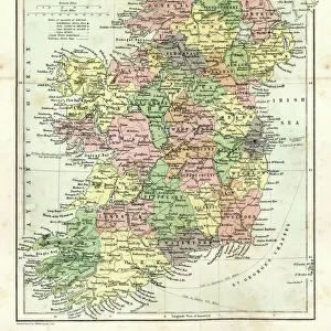
OS map, 1922: Isle of Man, Westmorland (colour litho)
")
![]()
Wall Art and Photo Gifts from Fine Art Finder
OS map, 1922: Isle of Man, Westmorland (colour litho)
8645549 OS map, 1922: Isle of Man, Westmorland (colour litho) by English School, (20th century); Private Collection; (add.info.: Isle of Man, Westmorland. Illustration for the Ordnance Survey Map of England and Wales, Quarter Inch to the Mile (1922).); © Look and Learn
Media ID 38388802
© © Look and Learn / Bridgeman Images
Isle Of Man Stereoscopic Card Stereoscopy 1920s 20s 20s
FEATURES IN THESE COLLECTIONS
> Arts
> Artists
> I
> Irish School Irish School
> Europe
> Republic of Ireland
> Maps
> Europe
> United Kingdom
> England
> Maps
> Europe
> United Kingdom
> England
> Westmorland
> Europe
> United Kingdom
> Maps
> Europe
> United Kingdom
> Northern Ireland
> Maps
> Europe
> United Kingdom
> Northern Ireland
> Posters
> Europe
> United Kingdom
> Northern Ireland
> Related Images
> Europe
> United Kingdom
> Wales
> Maps
> Europe
> United Kingdom
> Wales
> Posters
> Fine Art Finder
> Artists
> English Photographer
> Fine Art Finder
> Artists
> English School
EDITORS COMMENTS
This stunning color lithograph print of an OS map from 1922 showcases the Isle of Man and Westmorland in intricate detail. The English School artist behind this piece captures the essence of these regions with precision and artistry.
The Ordnance Survey Map of England and Wales, Quarter Inch to the Mile (1922) is brought to life through this vibrant illustration, offering a glimpse into the past and providing valuable historical insight. The early twentieth century mapping techniques used here are a testament to the dedication and skill of cartographers during that era.
As we study this map, we are transported back to a time when navigation relied on paper maps rather than GPS technology. The meticulous attention to detail in every contour line, road network, and geographical feature is truly impressive.
The colors used in this lithograph add depth and character to the landscape, making it come alive before our eyes. From lush green fields to winding rivers, each element is carefully rendered for maximum impact.
This print serves as both a work of art and a valuable historical document, preserving the beauty and complexity of these regions for generations to come. It reminds us of the importance of cartography in understanding our world and appreciating its diversity.
MADE IN THE USA
Safe Shipping with 30 Day Money Back Guarantee
FREE PERSONALISATION*
We are proud to offer a range of customisation features including Personalised Captions, Color Filters and Picture Zoom Tools
SECURE PAYMENTS
We happily accept a wide range of payment options so you can pay for the things you need in the way that is most convenient for you
* Options may vary by product and licensing agreement. Zoomed Pictures can be adjusted in the Cart.