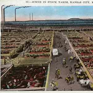
Home > North America > United States of America > Missouri > Kansas City
Comparison of the length of telegraph and railway networks of the countries of the World (coloured engraving)
")
![]()
Wall Art and Photo Gifts from Fine Art Finder
Comparison of the length of telegraph and railway networks of the countries of the World (coloured engraving)
6014051 Comparison of the length of telegraph and railway networks of the countries of the World (coloured engraving) by American School, (19th century); Private Collection; (add.info.: Comparison of the length of telegraph and railway networks of the countries of the World. Illustration from Crams Unrivalled Atlas of the World (Edward Williamson, Kansas City, Missouri, 1887).); © Look and Learn
Media ID 22812318
© Look and Learn / Bridgeman Images
Charts Comparison Countries Infrastructure Length Lines Nations Statistic Statistical Analysis Statistics Telecommunications Telegraph Networks
FEATURES IN THESE COLLECTIONS
> Fine Art Finder
> Artists
> American School
> Fine Art Finder
> Artists
> English School
> Maps and Charts
> Related Images
> North America
> United States of America
> Kansas
> Kansas City
> North America
> United States of America
> Missouri
> Kansas City
> Popular Themes
> Railway Posters
EDITORS COMMENTS
This print showcases a coloured engraving titled "Comparison of the length of telegraph and railway networks of the countries of the World". Created by American School in the 19th century, this artwork offers an intriguing glimpse into global infrastructure during that time period. The image is part of a private collection and originates from Crams Unrivalled Atlas of the World, published by Edward Williamson in Kansas City, Missouri, in 1887. It depicts an array of bar charts representing different nations' telegraph and railway networks. As we delve into this late 19th-century statistical analysis, we are transported to a world where communication and transportation were rapidly evolving. The charted lines symbolize both progress and connectivity as they crisscross continents. Through this visual representation, we gain insight into the vast differences between countries when it comes to their network lengths. This comparison highlights not only technological advancements but also economic development and geopolitical influence. The significance lies not only in understanding historical infrastructure but also appreciating how these networks shaped societies at that time. From facilitating trade to enabling faster communication across borders, these systems played pivotal roles in shaping our modern world. With its rich historical context encompassing geography, statistics, transport, telecommunications, and more; this print serves as a fascinating window into our past while reminding us how far we have come on our journey towards global connectivity.
MADE IN THE USA
Safe Shipping with 30 Day Money Back Guarantee
FREE PERSONALISATION*
We are proud to offer a range of customisation features including Personalised Captions, Color Filters and Picture Zoom Tools
SECURE PAYMENTS
We happily accept a wide range of payment options so you can pay for the things you need in the way that is most convenient for you
* Options may vary by product and licensing agreement. Zoomed Pictures can be adjusted in the Cart.