Home > Africa > Egypt > Maps
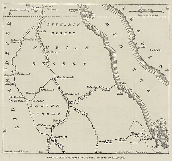
Map of General Gordons Route from Assouan to Khartoum (engraving)
![]()

Wall Art and Photo Gifts from Fine Art Finder
Map of General Gordons Route from Assouan to Khartoum (engraving)
1622396 Map of General Gordons Route from Assouan to Khartoum (engraving) by English School, (19th century); Private Collection; (add.info.: Map of General Gordons Route from Assouan to Khartoum. Illustration for The Illustrated London News, 16 February 1884.
English School (19th Century)); Look and Learn / Illustrated Papers Collection
Media ID 23555472
© Look and Learn / Illustrated Papers Collection / Bridgeman Images
FEATURES IN THESE COLLECTIONS
> Africa
> Egypt
> Related Images
> Fine Art Finder
> Artists
> English School
> Maps and Charts
> Related Images
EDITORS COMMENTS
This engraving, titled "Map of General Gordons Route from Assouan to Khartoum" takes us back to the 19th century and offers a glimpse into an extraordinary journey. The map, created by the English School, showcases the route taken by General Gordon as he traveled from Assouan to Khartoum in Egypt. The intricate details on this print allow us to trace General Gordon's path through the vast landscapes of Egypt. From the bustling city of Assouan, we can follow his footsteps along winding rivers and across arid deserts until reaching the historic city of Khartoum. This map not only serves as a geographical guide but also provides historical context for one of the most significant expeditions during that era. As we study this engraving, we are transported back in time and can almost feel ourselves accompanying General Gordon on his daring adventure. The sheer magnitude of this undertaking becomes evident when observing how far he had to traverse through unfamiliar territories and challenging terrain. This particular print was originally featured in The Illustrated London News on February 16th, 1884 – a testament to its significance even during its own time. Now preserved within a private collection, it continues to captivate viewers with its rich historical narrative and artistic precision. Whether you are an enthusiast of maps or simply intrigued by tales of exploration, this remarkable engraving is sure to ignite your imagination and transport you into an era long gone but forever etched in history.
MADE IN THE USA
Safe Shipping with 30 Day Money Back Guarantee
FREE PERSONALISATION*
We are proud to offer a range of customisation features including Personalised Captions, Color Filters and Picture Zoom Tools
SECURE PAYMENTS
We happily accept a wide range of payment options so you can pay for the things you need in the way that is most convenient for you
* Options may vary by product and licensing agreement. Zoomed Pictures can be adjusted in the Cart.


