Home > Asia > Palestine > Maps
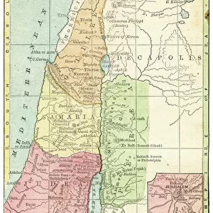
Map of the Twelve Tribes of Israel, Canaan, or Palestine, as it was divided between the twelve tribes of Israel. After a map published in 1750 (map)
")
![]()
Wall Art and Photo Gifts from Fine Art Finder
Map of the Twelve Tribes of Israel, Canaan, or Palestine, as it was divided between the twelve tribes of Israel. After a map published in 1750 (map)
6117853 Map of the Twelve Tribes of Israel, Canaan, or Palestine, as it was divided between the twelve tribes of Israel. After a map published in 1750 (map); Photo © Ken Welsh. All rights reserved 2024
Media ID 38278858
© Photo © Ken Welsh. All rights reserved 2024 / Bridgeman Images
Archival Archive Belief Canaan Countries Divided Geographical Israel Israeli Palestine Torah
FEATURES IN THESE COLLECTIONS
> Asia
> Israel
> Related Images
> Asia
> Palestine
> Related Images
> Fine Art Finder
> Artists
> English School
> Maps and Charts
> Early Maps
EDITORS COMMENTS
This stunning print captures the intricate and detailed Map of the Twelve Tribes of Israel, Canaan, or Palestine as it was divided between the twelve tribes of Israel. Dating back to a map published in 1750, this historical piece offers a glimpse into biblical times and the geographical layout of ancient lands.
The map showcases the territories allocated to each tribe, providing insight into the rich history and religious significance of these regions. From Judah to Benjamin, each tribe's boundaries are clearly delineated on this illustration.
As we gaze upon this archival treasure, we are transported back in time to an era when these lands were inhabited by the descendants of Jacob. The intricate cartography serves as a reminder of the deep roots that connect modern-day Israel with its ancient past.
Whether you are a scholar studying biblical history or simply appreciate fine art, this print is sure to captivate your imagination. Let yourself be drawn into a world where faith and geography intertwine, creating a tapestry of beliefs and traditions that have stood the test of time.
MADE IN THE USA
Safe Shipping with 30 Day Money Back Guarantee
FREE PERSONALISATION*
We are proud to offer a range of customisation features including Personalised Captions, Color Filters and Picture Zoom Tools
SECURE PAYMENTS
We happily accept a wide range of payment options so you can pay for the things you need in the way that is most convenient for you
* Options may vary by product and licensing agreement. Zoomed Pictures can be adjusted in the Cart.