Home > Europe > United Kingdom > England > London > Museums > National Maritime Museum
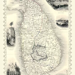
Chart of the Indian Ocean, c.1722 (coloured engraving)
")
![]()
Wall Art and Photo Gifts from Fine Art Finder
Chart of the Indian Ocean, c.1722 (coloured engraving)
7339427 Chart of the Indian Ocean, c.1722 (coloured engraving) by Delisle, Guillaume (1675-1726); 42x54 cm; National Maritime Museum, London, UK; (add.info.: Creator: Guillaume de L'Isle
Indian Ocean map showing the bay of Bengal and the northern tip of Sri Lanka (Ceylon).); © National Maritime Museum, Greenwich, London
Media ID 38101566
© © National Maritime Museum, Greenwich, London / Bridgeman Images
FEATURES IN THESE COLLECTIONS
> Asia
> Sri Lanka
> Related Images
> Europe
> United Kingdom
> England
> London
> Boroughs
> Greenwich
> Europe
> United Kingdom
> England
> London
> Museums
> Greenwich Heritage Centre
> Europe
> United Kingdom
> England
> London
> Museums
> National Maritime Museum
> Europe
> United Kingdom
> England
> London
> Towns
> Greenwich
> Europe
> United Kingdom
> Heritage Sites
> Maritime Greenwich
> Europe
> United Kingdom
> Maps
> Fine Art Finder
> Artists
> Francois-Joseph Belanger
> Fine Art Finder
> Artists
> Guillaume Delisle
> Maps and Charts
> Early Maps
EDITORS COMMENTS
This stunning colored engraving from 1722 depicts a detailed Chart of the Indian Ocean, created by the renowned cartographer Guillaume de L'Isle. The map showcases the bay of Bengal and the northern tip of Sri Lanka (Ceylon), providing a fascinating glimpse into the geographical knowledge of the time.
The intricate details and vibrant colors used in this engraving bring to life the vast expanse of the Indian Ocean, highlighting its importance as a major trade route and cultural crossroads in the 18th century. The careful craftsmanship and precision evident in this map reflect both artistic skill and scientific accuracy, making it not only a beautiful piece of art but also an invaluable historical document.
As we gaze upon this ancient chart, we are transported back in time to an era when exploration and discovery were at their peak. The meticulous attention to detail in mapping out coastlines, islands, and ocean currents is truly impressive, serving as a testament to human curiosity and ingenuity.
Whether you are a history buff, a lover of maps, or simply appreciate fine art, this print of Chart of the Indian Ocean is sure to captivate your imagination and inspire wonder at the vastness and complexity of our world.
MADE IN THE USA
Safe Shipping with 30 Day Money Back Guarantee
FREE PERSONALISATION*
We are proud to offer a range of customisation features including Personalised Captions, Color Filters and Picture Zoom Tools
SECURE PAYMENTS
We happily accept a wide range of payment options so you can pay for the things you need in the way that is most convenient for you
* Options may vary by product and licensing agreement. Zoomed Pictures can be adjusted in the Cart.